The Djalal Abad Oblast
Djalal Abad lies in the South West of the Kyrgyz Republic, bordering Uzbekistan, and the Kyrgyz oblasts of Talas, Osh, Naryn and Chui.
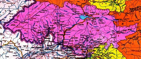
Map of the Djalal Abad oblast
Statistics: Area – 33648 square kilometers – Population – 842,000
Climate – The climate is noted for dry hot summers and sunny autumns with rare bursts of rainfall. The average temperature is around +27C in July (but may rise as high as 40 or 43C) and about –1.5 (and can be -4 to -10C) in January. The average rainfall is about 450 mm.
Landscapes – the oblast borders Uzbekistan along the Ferghana valley. The mountains rise up from the valley floor and the mountains slopes are rich in vegetation. The region is a centre for growing fruit and vegetables.
In the western part of the oblast is the long Chatkal valley. Nestling in Chatkal mountains are a number of lakes – including the pristine, beautiful, Sary Chelek.
The main Bishkek Osh road travels through the oblast past the large Toktogul reservoir. Cotton, rice, tobacco, vegetables, fruit and walnuts are all grown here and Kara Suu, one of the valleys on the edge of the Sary Chelek biosphere reserve, has been described as “a cultural landscape where man is important but nature dominates”.
Reserves :
- The Besh-Aral state reserve was founded in 1979 in the extreme South West corner of the oblast, (right on the border with Uzbekistan), with the purpose of preserving the unique natural complex and forests of the Chatkal valley, as well as to partially protect the habitat of the Menzbir marmot and to protect the natural habitat of vegetation of Greig and Kauffman tulips.
- The Sary-Chelek biospherical reserve occupying some 23868 hectares was founded in 1959 with the purpose of preserving the forests and mountain landscapes that surround lake Sary-Chelek. It contains over 1000 species of plants, including wild varieties of many “ancestors” of commercially important plants. About a third of the protected area remains as forest.
- Padasha Ata reserve in the Djalal Abad oblast, is one of the newer reserves dedicated to protecting the forest ecosystem in one of the most beautiful corners of the Western Tien Shan.
- The Saimaluu Tash State Park – was established in 2001 in the Eastern part of the oblast along the Kurart river. It is most famous for the petroglyphs found here but it is also important for its biodiversity.
Main Towns – Djalal Abad, Kara kul, Toktogul, Maili Suu and Tash Kumyr
Most of the rural settlements are located in the low-lying, fertile, Ferghana valley. Toktogul, Toguz Toru and Chatkal are the most remote of the settlements in the oblast – although Toktogul is on the main Bishkek-Osh highway.
Places to visit include:
- Djalal Abad, the regional center, is a lively town with a famous sanatoria.
- The walnut forests of Arslan Bob are known as the “Royal Woods” and Alexander the Great is thought to have found the trees here so enticing that he sent samples back to Greece.
- Sary Chelek is the largest of a series of small lakes and the area is protected to help preserve the special features of the eco-system found here.
- The Besh Aral State Reserve is another area of outstanding natural beauty.
- The Chatkal valley was once popular with sportsmen for training – and is virtually unexplored by modern tourists.
- Safed Bulan is home to the mausoleum of Shah Fazil, who is thought to have brought Islam to Central Asia.
- Saimalu Tash (the “Stonehenge of Central Asia”) presents a bewildering collection of petroglyphs that bear witness to a way of life that existed here over 4000 years ago.
.
Some other places of interest in the oblast:
- Aflatun : On the South Eastern slopes of the Chatkal mountain range.
- Ak Unkur : A cave by the river Bala Chichkan.
- Ala Bell Pass : At 3184 m one of the major passes on the Bishkek Osh road at the top of the Chichkan gorge.
- Ala Buka : Near the town of Ala Buka Safed Bulan.
- Arkyt : The village is well laid out, relatively well maintained and looks picturesque and is located within the boundaries of the Sary Chelek Zapovednik (Bio-diversity reserve) and, as such, offers a good base for visitors to the region with wide views on the surrounding mountains; an attractive river running through it; animals grazing freely; almost no cars and traffic; friendly people; fresh local produced food available and is relatively cool in summer and protected in winter. There is a museum is situated in a building next to the Zapovednik administration office which contains a topographical model of the Zapovednik, stuffed animals, insects and birds, and examples of different kind of trees and their timber. Labeling and descriptions are in Russian. A Community Based Tourism project operates in the village offering homestays and other services.
- Avletim : The Avletim valley has attractive gorges and forested mountains. There is a jeep track up an impressive gorge to a jailoo with extensive opportunities to explore the high mountain areas.
- Chaar Tash : The Chaar Tash petroglyphs are in a remote region, North of the Naryn River, near the point where the borders of Djalal Abad, Chui and Naryn oblasts meet.
- Chichkan : (= “mouse” in Kyrgyz) The Bishkek-Osh road follows the Chichkan river between Suusamir and the Toktogul reservoir. The river flows into the reservoir just West of the town of Toktogul on the northern shore. There is a nature reserve here, and off the tributary Bala Chichkan in the south of the Chichkan valley is the Ak Unkur cave. There are two high mountain lakes (at an altitude of over 3300 m), and one of them features a 60 m. waterfall. There is a yurt camp and guest house run by a Bishkek based tour company in the valley.
- Chunkurchak : In the Chatkal range, East of Lake Sary Chelek, – a collection of seven mountain lakes.
- Djani Bazar : At the Southern extreme of the Chatkal valley the road from Djalal Abad and Tash Kumir swings North towards Talas and here lies the town of Djani Bazar. Nearby is the Idris-Paygambar mausoleum (dating from the 13th century) built for a pilgrim from Damascus who came to Central Asia to seek enlightment. Several hundred Muslim pilgrims visit this site each year some from far away. A small basic hostel for pilgrims has been built near by.
- Jylgyn : The village of Jylgyn lies in the “buffer zone” which surrounds the Sary Chelek Zapovednik (Biodiversity reserve) and lies 7km from the entrance to the park. The Sary Chelek Tourbaza (holiday camp) is found here. The tour base was established by the Federation of Trade Unions in 1974 and was the largest tour base in South Kyrgyzstan in Soviet times and was the most important source of tourists to Sary Chelek Zapovednik. It was deliberately established outside the reserve itself, to help reduce pressures on the park – and access was supposed to be strictly controlled – but apparently it wasn’t as strictly controlled as it should have been.
- Kalmak Kirchin : A small village about 60 km northeast of Djalal Adab, which is the starting point for a visit to Saimaluu Tash.
- Kambarata : The Kambarata Canyon lies to the South of the Naryn River, just before it reaches the Toktogul Reservoir. With high, rocky cliff walls offering limited observation points, rapids and whirlpools – it is a popular spot for white water rafting.
- Kara Jygach : Among the natural sights to the South of Lake Sary Chelek is Kara-Jygach, which is just one example of a beautiful geological feature, stone columns moulded by the forces of erosion and the Padysha Ata canyon which presents a picturesque view of an beautiful pristine mountain landscape – it is also a place of pilgrimage.
-
Kara Kul : A dormitory town for the workers at the main Toktogul power station, which is nearby. It is possible to arrange tours of the dam and power station, which is one of a series of five across the River Naryn through the gorge down to Tash Kumir.The dam was completed after 14 years construction in 1976 – and it features on the 100 som note. Yet more dams are planned – but it is not clear when and if these plans will be implemented. As well as being a major producer of electricity, which Kyrgyzstan exports to neighbouring countries – it has also been the source of much dispute with Uzbekistan, which lies further down the river – as Kyrgyzstan controls the flow of water which is needed for irrigation of cotton fields etc. in Uzbekistan. At one point the Uzbek armed forces apparently held exercises, which looked suspiciously like a rehearsal for seizing control of the dam.
Just to the North, a “golden tiger” ornament was discovered.
- Kara Suu : Two lakes at an altitude of 1998 m, set amongst fir forests and meadowland. There are a number of small villages along the valley with Community Based Tourism accommodation and other services. A jeep track leads 3 km above Kyzyl Kol, which offers opportunities for trekking and horse riding over three passes to the northern and southern ends of Sary Chelek Lake and to Arkyt in summer months. Other horse trails and trekking routes up the valley to Kara Kamych Lake and on into the Chatkal valley through the Sary Chelek bio-reserve, through the beautiful Jarik Tash valley and to Toktogul are also possible. The valley is populated, with many small farms along the river. Many of them have been established since 1999 and some even lack electricity. It has been described as “a cultural landscape where man is important but nature dominates”.
- Kara Tokoi : In the Chatkal Range, North of Lake Sary Chelek – an area with a great number of high altitude mountain lakes. Cliff paintings of wild animals (dating from the 1st and 2nd centuries) are found here at a height of 3000 m.
- Kazarman : Kazarman has the reputation of being a “Wild-West” type of town – possibly because of it’s connections with the nearby open-cast gold mining and refining facilities. It is located on the main road between Naryn and Djalal Abad and serves as a stopping point on this journey. The 150 kilometer section to Djalal Abad is only open for four months of the year because of the weather conditions, (for example, snow covering the high passes), and the state of the road surface – although road works were undertaken in 2003 with a view of extending this to six. Even when it is open – the journey from Djalal Abad to Naryn takes about 18 hours and is not an easy drive (even if the scenery can be spectacular). The Naryn river flows by, and the mountains that surround the town are. They are said to be good for hunting and fishing. To the South lies one of the access points for Saimaluu Tash. There is a Community Based Tourism project based here which can organize accommodation and other services.
- Kerben : Also known by it’s Russian name – Caravan. This small town stands on the crossroads between Sary Chelek, Uzbekistan, the Chatkal valley and the road to the East connecting with the main Bishkek-Osh road. A statue of Karl Marx overlooks the crossroads at the center of the village. It was the center of controversy in 2002 when, at a protest meeting against the government, six protesters were shot by police. On the way to Sary Chelek there is a poignant memorial to those killed.
- Koja Ata : The valley leads into the Sary Chelek Bio-reserve.
- Kyzyl Unkur : (= “Red Cave” in Kyrgyz) Fifteen kilometers from Arslan Bob. Situated in nut woods, there is a hunting reserve around the nearby Yassa river. There is a small holiday camp here.
- Naiza : By a tributary of the Chatkal river a number of petroglyphs, (predominantly of goats) can be found.
- Padsha-Ata : Not far to the north of Kerben . This is a gorge and fast flowing river up stream from Kashka-Suu. A road runs along the gorge to Karabashat village and Saint Padsha-Ata Mazar (18-19C). A road runs along the gorge to Karabashat village and Saint Padsha-Ata Mazar (dating from the 18th and 19th centuries). A spectacular area with thick birch groves running along the course of the river. The valley narrows and the power of the water increases, turning huge stones loudly, in a white mist of water vapour. Passing through the gorge the valley widens and the sides are covered with thick Tien-Shan fir forests. White birches line the banks with other assorted shrubs. Several tributaries join the main river cascading through narrow canyons with walls up to 400 m high. After another gorge the river opens out at 2000 m to flood across a wide meadow with a beautiful fir grove. Snow fields and a small glacier with three mountain peaks over 4 km, are seen to the north.
- Ortok : a village about 60 kilometers northwest of Djalal Abad, set in one of the densest forest regions in Kyrgyzstan. – surrounded by mountains and mountain meadows. There is a wide variety of flora – trees, grasses and other plants – and fauna. About 6 kilometers outside the village is a cliff with an extensive, labyrinth, cave system. There is a Community Based Tourism group based in the village, which can provide accommodation and other services.
- Sargyr Pass : At 3100m this is the highest point on the 177 km road between Kazarman and Djalal Abad and clearly marks the distinction between a spectacular road clinging to the mountain side and fertile mountain valleys. The pass is closed for most of the year by snow.
- Tash Kumir : A coal mining town which stretches for several kilometers on the side of the Naryn River below the Toktogul reservoir which serves as a starting point for trips into the Sary Chelek reserve. The Bishkek-Osh road between the reservoir and Tash Kumir passes through a spectacular gorge. Nearby is Kara Suu where archaeologists have discovered the remains of a stone age settlement.
-
Toktogul : A small town located on the Northern shore of the Toktogul Reservoir – named for it’s famous son – the akyn Toktogul Satilganov (1884-1933).The reservoir was created in 1974 – after 14 years construction work on the Toktogul Dam was completed – when the Ketmentube valley was flooded. Some 26 communities were displaced and relocated along the main road which was forced to swing round the Eastern end of the reservoir when the valley was flooded, and archaeologists completed several excavations of barrows dating from the 8th and 9th centuries.
The southern reaches of the reservoir (just North of the town of Tash Kumyr) is in the form of a flooded canyon which is about 0.3-2 km wide – and can reach as much as 100 m deep. Elsewhere there are many shallow areas with abundant vegetation, which serves as a habitat for wildlife.
In January 2004, the Vecherniye Bishkek newspaper carried an interesting story about some Bishkek residents who went fishing in the reservoir. The men knew the area very well and the waters where they were was only about a meter deep. The men felt the line snag on something. When they investigated they saw something grey, about 20 centimetres across. It looked like a snake – and when the line was eventually freed it was stripped of all the bait and catch that had been there. It was at this point that they remembered having been told by local people not to fish there as there was “a huge snake that can cut off something between your legs!” When asked what he thought it could possibly be, one of the fishermen is reputed to have said: “I have never seen anything like it in my life. But I know one thing: I will not go fishing to Toktogul Reservoir anymore!”
- Uyum Tash : On the way to Sary Chelek – renowned as an ancient place of judgment. A person who had committed lots of sins would try to pass through he would get stuck, squeezed or crushed but a pure person would pass through unharmed. If someone was suspected of lying or stealing, they were asked to visit this place – and the fear this potential experience could inspire was sufficient to lead to full confessions
- Uzun Akmat : In the Azun Akmat canyon there is a Forest reserve of 500 hectares, with a “hunting farm”, and several historical monuments.




 Bishkek