Going South – Osh oblast
Back in 1972, on 24th November, the Osh oblast was created.
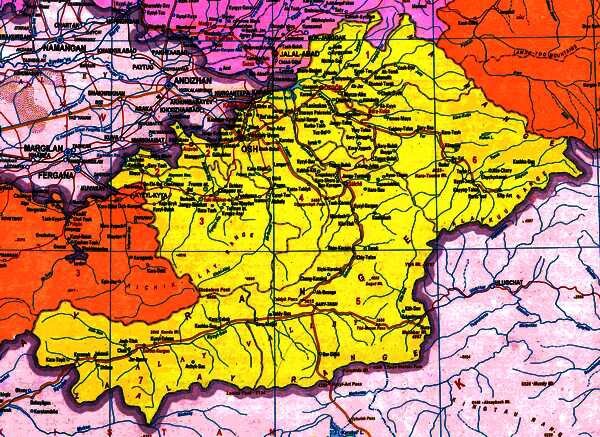
The Osh oblast
Osh is in the Southern part of Kyrgyzstan, bordering China, Uzbekistan and Tajikistan as well as the Kyrgyz oblasts of Batken, Djalal Abad and Naryn.
Possibly because we are based in Bishkek, in the North of the country, most of the requests we receive for visits to Osh are trips which involve border crossings … for example, along the Great Silk Road between the ancient cities of Uzbekistan in the Ferghana Valleyand Kashgar in China, over the Irkeshtam Pass, or down the Pamir Highway in Tajikistan,over the Kyzyl Art Pass.
That’s not to say, however, that there isn’t plenty to see and do in the region.
Statistics:
Area – 29200 square kilometers
Population – 1,272,600
Climate
Bordering the Ferghana Valley, sometimes described as semi-desert – the oblast enjoys hot summers, but also mild winters. The average temperature is around +25C in July and about –4 in January. The city of Osh boasts the only positive average annual temperature in the country. The average rainfall is about 300 mm.
Landscapes
The city of Osh lies at the head of the Ferghana valley and the oblast forms the southern flank of the valley – with the Altai mountains rising to Peak Lenin on the border with Tajikistan.
Reserves
The National Natural Park “Kara Shoro” was established in 1996 with 8,450 hectares – most of it pasture land, but containing some 823 hectares of forest. There are no roads in the park itself.
The Kyrgyz Ata State Park was founded in 1992 with 1,172 hectares to preserve the local, natural archa (juniper) forest.
Main Towns
Osh - the “southern capital” of the the republic.
Uzgen - an important center on the trade routes between the Ferghana and Semirechye (Seven Rivers region)and it is claimed that it is one of only two cities in Kyrgyzstan to have existed continuously from its foundation in ancient times to the present.
Places to visit
- The centerpiece of the city of Osh, itself, is the Suleyman Mountian which rises majestically to watch over the metropolis, but there are number of other sites – and the lively market stretching along the banks of the Ak Buura river.
- Uzgen, another ancient settlement, is home to some archaeological monuments – a tower, and some mausoleums; dating from the 11th century;
- Chil Ustin is the center for a series of spectacular caves;
- Aravan, the home of “The Celestial Horses” depicted in petroglyphs.
- The Irkeshtam Pass to China and Kyzil Art pass on the Pamir highway to Tajikistan.
- Peak Lenin lies on the southern border with Tajikstan.
Also:
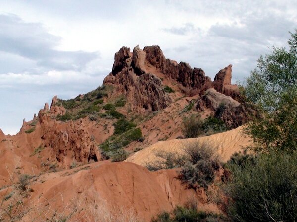
- Abishir-Sai Canyon : About an hour’s drive to the West of Osh, in the Nookat district, is a picturesque canyon – with steep rocky sides, with the river Abishirsai flowing though it. The river emerges gushing from a cave in the rock face and falls through 30 m to the valley floor. The waters of the waterfall are thought to have curative properties and be holy. Pilgrims come from far and wide to bath in the spray and collect the water in bottles. Nearby is a hermit’s cave and there is a legend of the holy man Idris turning the water into milk – then back to water again because it was of more use to the people than milk.
- Achik Tash : A climbers camp on Peak Lenin.
- Ak Terek : The village is located in the foothills of the Kara-Shoro park, by the Jassy river. There are many mineral springs nearby and the gorge is covered with walnut forests. There is a group of residents, supported by the British Department for International Development, which can offer accommodation and other services, including a 6 day to jailoos of Besh Terek (=”five poplars”), Kara Dobo (= “Black hill”) Baibiche and trek through the Kypchylma Pass (Kypchylma = “squeeze through” in Kyrgyz) to the Chytty jailoo ( = “cotton fabric”) where there are the remains of an ancient Chinese/Kyrgyz trading post – Sogolon caravanserai, which had walls some two meters thick and two and meters high – with six towers. Further on it passes through Balam Kaldy (=”my baby was left here” – there is a story that a mother, moving to another pasture, dropped a cradle with her child into an abyss and was sadly unable to retrieve it). The trek continues along the Jassy river through the Kara Shoro park, rich in wildlife. On the way through to the Arpa valley (= “barley”), the trek carries on through a number of other jailoos – Aga Tan, Echki Tal, Shibiluu and Kuljauyk.
- The Alai Valley : On the North side of the High Pamir mountain range. The Kyzyl Suu (=Red Water) river flows through the 150 km valley, which is some 60 km wide and runs east to west between the Pamir and Pamir Alai ranges of mountains. Once a major route on the Silk Road, now it is scattered with dusty villages and is visible even from the slopes of Peak Lenin.
- Alai Zhalpak Tash : Just off the road between Osh and Sary Tash, archaeologists excavated a glass cup.
- Chil Mairam : There are a lot of caves not far from Osh airport in the east of the mountains of Chil Mairam.
- Chili Sai Gorge : A little to the South of the small village of Eski Nookat – lies the Chili Sai Gorge, which contains a number of petroglyphs.
- Duldul Ata : There are ancient petroglyphs dating from about 1000 BC on the rocks of Duldul Ata – figures of race horses named in honour of the saint Ali – who, according to legend left them here.
- Kirkidan : To the West of Osh, close by the border with Uzbekistan, lies the site of an ancient settlement dating from between the 4th century BC and the 4th century AD.
- Kuhl Garmo : (=Warm Mountain) The new name given to Peak Lenin.
- Kyrgyz Ata : (= “Father of the Kyrgyz”) A national park in the mountains, south of the road between Osh and Kyzyl Kia, established to protect the archa forests which grow here.
- Kyzyl Art : The road south from Osh to Tajikistan passes through Sary Tash where it meets the road to Irkeshtam and China. Further South it passes over the Kyzyl Art Pass into Tajikistan. At 4282m above sea level – this is the highest road in Kyrgyzstan.
- Lukovaya Polyana : (= Wild Onion Field) The last greenery before the stony moraines of the mountain slopes of Peak Lenin.
- Mady : To the East of Osh, by the river Taldyk, lies the site of an ancient settlement dating from between the 10th and 12th centuries. The township of Mady was an important junction on the Silk Road, sometimes known in old texts by the name of Medva. It was situated on a high terrace from which much of the Ferghana valley – including the city of Osh – was visible. The original settlement was rectangular, measuring about 80m by 250m – with a citadel and a developed defensive system.
- It was the home of the Queen of the South – Kurmanjan Datka who is featured on the 50 som banknote.
- Sary Tash : A small village at the junction of the road from Osh to China – via Irkeshtam – and Tajikistan – via the Kyzyl Art pass.
- Shoro Bashat : Just inside the border with both Uzbekistan and Djalal Abad oblast lies the site of an ancient settlement which dates from the 4th century BC through until the 5th century AD.
- Surat Tash : There are ancient petroglyphs dating from about 1000 BC on the rocks of Surat Tash.
- Suuk Dobo : (= “cold hill”). In 2004, it was reported that a new field of Petroglyphs was discovered here which date back to a period between the 3rd and 1st centuries BC. Having heard stories from local shepherds about a place in the mountains which was visited by sick people at Siik Dobo a team of scientists decided to explore. After a journey which took four hours on horseback they found a stony tract, some 3500 meters above sea level, with a gallery of previously unknown petroglyphs on boulders and small stones. They discovered and catalogued some 1500 drawings, which seem to show a development from drawing animals such as the Argali (Marco Polo sheep), horses, camels, reindeer, bulls, wolves, dogs, wild boars and birds – whilst others depict hunting scenes, and others which seem to depict fire worship, and also some unknown graphic signs. (It is suggested that, to modern eyes, one looks like an airplane and another resembles a railway track).
- Talgyy Pass : Between Torugart and Irkestam, this mountain pass (3668 m.) once served as one of the main routes from China. Now the road from Osh stops short of the border at the village of Kek Art
- Terek Bawan Pass – This pass between Kyrgyzstan and China is not open as a border crossing today – but it was used, for example, in 1915, by Percy Sykes, and his sister Ella as they traveled to Kashgar where he was to take up the post of British Consul after a long train journey through Russia. Having arrived by train in Andijan (Uzbekistan) they were joined in Osh by some of their staff from the consulate in Kashgar and began the final leg of their journey – a 260 kilometer trek over the mountains. En route they met a large number of people – merchants bringing goods to trade.
- Tar Canyon : The river Tar is a tributary of the Kara Darya river which flows from the East to the South of Uzgen and then down into the Ferghana Valley. The canyon is rich with a variety of fauna and flora including shrubs and pistachio trees, two lakes, petroglyphs, a cave 910 m long and many springs of mineral water.





 Bishkek