Osh – the Southern capital of Kyrgyzstan
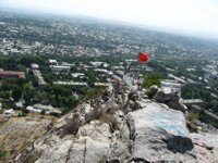
The city of Osh from Suleiman Too
Tomorrow, October 5th, is Dehn Goroda in Osh.
Osh is the second largest city in Kyrgyzstan – at the head of the Ferghana valley – and is often referred to as the Southern capital of Kyrgyzstan.
It is reputedly 3000 years old. Archaeologists have found artefacts dating back to about the fifth century B.C.
One claim that is often heard is that Osh is “Older than Rome”. There are several legends about the origin of the city – including claims to having been founded by Solomon or Alexander the Great. Even if such a grand personage did not establish Osh, its position at a crossroads along the ancient trading routes that became known as the Silk Road almost guaranteed that it would become a major settlement.
Osh is mentioned in the greatest epic of the Kyrgyz People – Manas – where the wise man Oshpur was a tutor of Manas.
In the period between the 10th and the 12th centuries it was the third city of the Ferghana Valley, and in 1762 it joined the Khanate of Kokand and became one of the six trading centres with the Khanate. Assimilated into Tsarist Russia, the city expanded onto the left bank of the river and European style houses started to appear.
The city is the administrative centre of the Osh oblast, at the head of the Ferghana valley and lies close to the border with Uzbekistan. A large number of travellers along the Silk Road use the nearby Dostuk (or Doslik) border crossing.
The mountain ranges that criss-cross the country effectively divide the North from the South and many say that the Kyrgyz in the South are quite different from those in the North – more independent and proud than those they as Russified Northerners.
There are really only two North-South routes – the main Bishkek Osh road and the Bishkek-Torugart road.
For the record: There is also the spectacular Bishkek-Osh highway – currently undergoing repairs that can cause havoc to plans as parts of the road can close to allow maintenance work to continue at odd times. The road may be spectacular – but it can also be dangerous with many accidents (and fatalities) each year. In 2001 – a number of people died from fumes in the Tuu Ashu tunnel after a car broke down halting traffic. The Tuu Ashu pass (actually Ashu means “pass” in Kyrgyz) is the highest point on the road at 3586m – and the gorge to Kara Balta is well worth the journey in itself. The other side of the pass is the plain of Suusamyr – and then continues past the Toktogul reservoir and hydroelectric power station that is featured on the 100-som note. Travelling on South and then East to skirt around the Uzbek part of the Ferghana valley, the road passes the turn off to Arslan Bob – where there are groves of ancient Walnut trees and it is from here that Alexander the Great is supposed to have sent samples of the tees back to Macedonia – and eventually comes to Djalal Abad. A bit further on is Uzgen where there are some archaeological ruins (mausoleums and a tower – minaret – that are featured on the 50-som note.
The fact that there is only one road linking the city with the capital, its proximity to the border and the large number of ethnic Uzbeks in the local population means that sometimes this area seems to be more attuned to its neighbour than to Kyrgyzstan itself.
The differences between the two nationalities, (Kyrgyz and Uzbek), came to a head in 1990 when riots in a village not far from the city left over 300 dead, many more injured, and considerable damage to property – and again in June 2010 following the Revolution in Bishkek, when approximately 500 people died in several days of chaotic fighting and disorder.
There are several flights a day between Bishkek and Osh – and also flights from Osh to Kashgar, the United Arab Emirates and several cities in Russia.
The Ak-Buura river runs through the city North to South.
In the center of the city is Suleiman Too (“Solomon’s mountain”), which dominates the city. Up until the sixteenth century it was known as “Bara Kuch” – or “Nice Mountain”. It was given it’s new name because the Muslim prophet Suleyman Sheikh was buried at the foot of it, and since that time it assumed a Holy significance and many believers make a pilgrimage here. Also, some Muslims apparently think that Muhammad is supposed to have once prayed here.
There is a path walkway around the mountain, which makes an interesting walk. Along the way you will probably see pilgrims praying at a little cave. Inside the cave, water droplets drip from the roof, and it is said that these are the tears of Suleyman. Pilgrims come to pray to relief from illnesses and for help in solving problems.
For some reason (apparently, in profile some people think it resembles a pregnant woman lying down – but you have to be some distance away and in the direction to see this), it is also revered by many women who have been unable to bear children.
At the top of a short (30 minute climb) is a flagpole and a mosque built in 1497 by the 14 year old Babur who had been recently crowned the King of the Ferghana Valley – and later went on to become the founder of the Mogul dynasty in India – destroyed and rebuilt twice it is another center for pilgrimage. In later life Babur abdicated and wrote his memoirs in which he mentions the Suleyman mount (and his building projects on it); the river, overlooked from both banks by gardens and a red and white stone which was used as handles for knives. He also tells of a mosque built by a meadow with a wide wide stream flowing through it, and apparently it was a standing joke to carry people who fell asleep in the meadow across three streams to the other side.
There is also a small archaeological-cultural museum here with many of the ancient artefacts discovered in the city environs. An historical-ethnographic museum called the Great Silk Road Museum, on Kurmanjan Datka, has well-done exhibitions which focus on South Kyrgyzstan and cover the Silk Road days; Kyrgyz immigration from South Siberia; the Kokand khanate; Russian annexation in 1865 and the Bolshevik takeover after 1917. One interesting exhibit is a map dating from 1953 that shows the different Kyrgyz tribes and clans (still a very important factor in Kyrgyz society today).
In the city there is a statue of Kurmanjan Datka – the “Queen of the South” who opposed Russian expansion in the region and is featured on the 50-som note. There is also a statue of Lenin. Nearby is a war memorial that bears the inscription (in Russian and Kyrgyz) “No One is Forgotten – Nothing is Forgotten”.
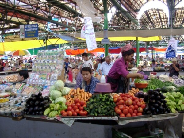
Most guidebooks refer to the bazaar as one of the most picturesque in all of Asia, stretching for about a kilometre along the bank of the river. Since the disorders of 2010, however, it has led a moire subdued existence in the life of the city.
Near the bazaar is the largest mosque in Kyrgyzstan – The Shaid Tepa Mosque. The original wooden building was constructed between 1908 and 1910, but was closed by the Soviets, when it served as a stables and blacksmiths. It was reopened in 1943 in a surprising act of religious tolerance by the then Soviet government. Recently it has been renovated with financial support from Saudi Arabia and has space for some 5000 worshippers.
Also worthy of note are the Rabat Abdul Khan Mosque – but apparently only if you are a suitably dressed man – and the Russian Orthodox Church.
Some way from the city are some spectacular caves and the Pamir mountains … however since 1999 most embassies warn their nationals that it is best not to travel South and West of Osh because of incursions by armed guerillas in the far South West of the country where the borders of Tajikistan, Uzbekistan and Kyrgyzstan meet – and the troubles on 2010.
For those with time to spare in Osh, not far from the city are the Caves of Chil Ustin and the petroglyphs of Avaran.




 Bishkek