Some places to see over the border – China

The Chinese Flag
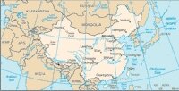
Kyrgyzstan is a small landlocked country with four neighbours: the former Soviet republics of Kazakhstan, Uzbekistan and Tajikistan … but it,s largest neighbour with which it shares a border is China – or to give it its proper name: The People’s Republic of China, (PRC).
The People’s Republic of China was founded on October 1, 1949 with a ceremony at Tiananmen Square and in December that year, October 1 was declared the country’s National Day. It is celebrated with a variety of government-organised festivities, including fireworks and concerts; public places, such as Tiananmen Square in Beijing, are decorated in a festive theme and portraits of revered leaders, such as Mao Zedong, are publicly displayed.
It marks the start of one of the “Golden Weeks” in the country when virtually everyone seems to go on holiday … The Torugart and Irkeshtam border posts tend to close for the week, (or ten days). The others are connected with the Chinese New Year and the May Day holidays.
China
The PRC is just the latest incarnation of the country – China is home to one of the world’s oldest continuous civilizations, which can be traced back to the 12th Century BC. At times a unified country with a huge empire that spread as far as Korea, Japan, South-East Asia, - Chinese expansion westwards was halted in 721 AD at the battle of Talas. At other times a weak leader or pressure from neighbouring powers would lead to the country being fragmented into smaller disparate kingdoms and states.
China is a vast country, there are 26 provinces, each with their own dialect and regional characteristics. The western provinces, (including Xinjiang, just over the border from Kyrgyzstan), occupy an enormous area of land. This means that visitors to the country can fave long travelling times between the different places of interest: cultural, historical and natural wonders.
There are indeed plenty of place to see and visit just over the border in Xinjiang … the most famous and nearest, of course, being the city of Kashgar - famous for its Sunday Market, but also the “Abakh Khoja Mausoleum”; the Id Kah Mosque; the Mor Buddhist Pagoda; the “Three Immortal Buddhist Caves” and “Shipton’s Arch”, (known locally as Tushuk Tash – “pierced rock”).
There is a lot more to see in the region, however, including:
Artush : Forty kilometres from Kashgar, Artush is the administrative center for the Kizilesu Kyrgyz Autonomous County. Outside the town is the Sultanjiamai Mosque and the tomb of the first ruler of Kashgar to convert to Islam – Satuq Bugara Khan – although the original, grand, edifice was destroyed in an earthquake and the modern one is fairly recent.
Hotan : To the South of the Taklamakan Desert – a center of the silk trade. There is lively Sunday market which some say is as varied and interesting as the one in Kashgar. Among the interesting sites in and around Hotan are:
- The Hetian District Museum – is on Tanayi Nan Lu next to the jade factory. Although it is a small museum it houses a large quantity of artifacts, including pottery animals and figures, clay figurines, coins, clothing, silk and carpet fragments, fresco samples, jade lamps, Tibetan bronzes, jewelry, chased silver and gold utensils, documents and carved wooden beams from the Niya ruins. The museum also exhibits well-preserved mummified corpses of two Buddhist monks, one in his 30s and the other a teenager. The feet of the fifth or sixth century AD mummies are bound to keep them resting in peace instead of wandering.
- The Ancient City of Mallikurwatur – which is also known as the Mallikurwatur Ruins, is an ancient city lying 25 km southwest of Hotan, on the west bank of the Jade Dragon Kashgar River. There is some dispute about whether it is the ruins of an ancient city from the Yutian Kingdom or a monastery compound. Since 1977, various excavations have discovered a variety of ancient objects including potsherds and ancient coins.
- The Ancient City of Niya – The ancient city of Niya is 150 km from Minfeng, an oasis in the Taklamakan Desert. The ruins are believed to be of the ancient Kingdom of Jingjue, one of the oasis states recorded in the Chinese Han Dynasty chronicles. However, the city vanished sometime between 500 and 1000 AD. The ruins were discovered in 1901 by the British explorer Aurel Stein. In 1993 and 1995, two Sino-Japanese expeditions unearthed other previously undiscovered ruins. At the heart of Taklamakan Desert, some existing wooden structures, including houses with courtyards, stables, graves, and clay Buddhist stupas, and even a bridge. In the residential quarter, the team also found jewelry, bronze mirrors, coins, arrowheads, household utensils and wooden tablets written in the long dead Kharoshthi script. Preserved beneath the sand, some naturally mummified corpses resting in hollowed-out tree trunks were excavated in the city ruins too (leading to comparisons with Pompei). Those corpses together with other findings indicate the city was once a place where Chinese met with Indians and Europeans – and was a place of trade and cultural exchanges. Although evidence indicates that it was the encroaching desert that destroyed the once prosperous city, enemy invasions might also have contributed to its demise.
- The Ancient City of Yotkan – is situated about 10 km from Hotan and covers about 10 square km, the ruins are believed to be the capital city of the ancient Kingdom of Yutian, one of the oasis states in the Chinese Western Region along the Silk Road. In 1892, a French explorer came and collected many artifacts including pottery and jade articles. In 1896 and 1900 Sven Hedin and Aurel Stein were attracted to the city where they excavated a lot of artifacts including some gold coins, gold leaves and Christian crosses.
Karakul (or Karakuri) Lake : is known as the father of glaciers. Lying at an altitude of 3600 meters above sea level, at the foot of Mount Maztagata, it offers unspoiled, dramatic and spectacular natural scenery. The surface of the lake reflects the snow-covered peaks of Mount Muztagata, which towers in the background. There is the possibility to take hikes or walks in the surrounding area, especially in summer when flowers are in bloom and the air is fresh and pleasant. However, it can get very cold at this altitude. For a walk around the entire lake you will need a whole day – and it is possible to stay overnight in a yurts, or camping.
Korla : lies on the 1400 km road between Urumqi and Kashgar and is often used as an overnight stop for those travelling overland. In the early 1990s it was a sleepy town, famous for pears, but has apparently undergone considerable development in the intervening period. The area was visited by travelers such as Younghusband, Le Coq, Auriel Stein and Sven Hedin. Among the sites of interest in the neighbourhood are:
- The Ancient City of Loulan – On the western shores of Lop Nur Lake, (which is now a lake of sand instead of water), the Ancient City of Loulan was founded in the 2nd century BC in an oasis with rich water network. After flourishing for about 900 years, it disappeared in the sixth century – to be rediscovered by Sven Hedin. The city has already totally collapsed into dust. The only recognizable structures are a pagoda which is the largest structure in the ruins, and a seems-to-be office which still has painted timber traces. Archaeologists believe there was once an undergroud water channel running through the city and dividing it into two functional parts. Large amounts of potsherds, wood pieces, coins, jewelries and wood slip documents are listed amongst the archaeological finds, which provide us many clues about life in the ancient city.
- Bayanbulak Grassland – a vast highland prairie about 270 kilometers northwest of Korla, which is home to the descendents of Mongols who came here from Russia about a hundred years ago. The natural splendor of the area testifies to the accuracy of its Mongolian name which means “Rich Fountains”. Bayanbulak’s considerable water supply supports the luxurious grasslands, numerous varieties of multi-hued flowers, and hundreds of thousands of cattle and sheep. It is the second largest grassland in China encompassing an area of 23 thousand sq. Km, and has the distinction of having the only nature reserve for swans in China and is one of the largest swan reserves in the world, (hence the area has a lake named Swan Lake – comprising of hundreds of small connected ponds that are fed by springs and streams and covers about 300 square kilometers). Nadam Fair is an annual grand Mongolian event that is usually held in June, (Its date varies somewhat each year as the time of the Fair is based on the lunar calendar.) The fair gives a chance to see horse racing, wrestling, dancing, and singing, as well as local foods, crafts, and other commercial wares that are specialties of this area.
- Bosten Lake – 57 kilometers northeast of Korla, is the largest freshwater lake in Xinjiang and serves as a natural reservoir. The lake covers over 1,000 square kilometers and is known as the Oriental Hawaii of Xinjiang because of its unique and beautiful scenery in the Gobi desert. To accommodate developing tourism, recreational facilities have been developed around the lake, offering motor boating, water-skiing, diving and fishing.
- Lop Nur – lies east of Korla and covers 3,000 square kilometers. It was an important station on the Silk Road and was once a very large lake. In the Han dynasty, Lop Nur was such a vast lake that it was often mistaken as the source of the Yellow River. Deforestation, however, and human activity so affected the lake that as early as the 4th century A.D. codes and regulations had to be introduced to control the use of the insufficient water. When Marco Polo reached Lop Nur in 1275, he found “nothing more than sand”. Its contraction continued and Lop Nur finally disappeared in 1972.
- Tiemen Pass (Iron Gate) – is just outside the city (about 8 kilometers north of Korla), and lies at the mouth of a 14 kilometer long valley. It was of strategic importance in the history of ancient China and is listed as one of the 26 famous Passes on the route. Tiemen was at the “throat” of the Silk Road and the traffic junction between northern and southern Xinjiang. Nearby, there are still traces of an ancient barracks. Four Chinese characters are inscribed on the cliff beside the pass, which describe the steepness of the pass. Nearby there are two graves in which a couple that died for love and freedom were buried. Tzuohla, Princess of the ancient Yanqi . The treacherous premier tried to kill her, and whilst trying to escape, the couple fell down the gorge.
- Yadan Spectacle – Yadan means “Steep Mounds” in Uygur, and refers to the special topography in this dry region. The clay-like rock became a series of ditches and ridges aligned in the direction of the prevailing wind, as an effect of strong water and wind erosion. These marvelously shaped ditches and ridges, usually extending for many metres, even hundreds, form a spectacular view. In Lop Nur, a similar feature is called “Dragon City”, which covers some 3500 square metres.
Taklamakan Desert : In the Tarim basin of Xinjiang province lies the Taklamakan Desert. This vast expanse of sand surrounded by lush oases was referred to in the time of the Han dynasty as “Liu sha” (= “moving sands”), due to the constantly drifting sand dunes driven by fierce, relentless winds. The modern name “Taklamakan” means in Uighur: “enter and never return”. Ancient cities once flourished in the areas now overtaken by the desert – and there have been many expeditions into the interior, which have found incredible treasures. There is a North South road crossing the desert which would have been a boon to explorers like Sven Hedin who nearly perished here, and it is possible to arrange a day trip from Kashgar, with the opportunity for a couple of hours riding camels to capture the atmosphere of both the Silk Road and the experiences of early explorers.
Tashkurgan : Tashkurgan, (= “stone city” or “stone fort”), lies in the extreme South-West of the province of Xinjiang, in the Tajik Autonomous County. At an altitude of 3600m, it lies at the foot of the road leading to the Kunjerhab Pass, the Karakoram Highway – and Pakistan. In fact, the only road to Tashkurgan which is open to foreigners is the main one from Kashgar to Sost on the Pakistan side of the border and the town houses the border crossing post with customs and immigration. (Technically, the border is open from April 15th until October 31st – although these dates can move due to weather conditions.) It’s position gave the town an importance, as it marked the entrance to China proper from the South Asian continent – especially from British India in the days of the Great Game. Younghusband (the explorer) and Macartney (probably the most famous of the British consuls in Kashgar) arrived here in 1890. Safdar Ali, the deposed ruler of Karimabad arrived here, fleeing from advancing British troops, in 1891. Just before the First World War, the russians occupied the fort with a contingent of Cossacks.
The town maintains a colourful and interesting atmosphere – with contrasting elements between the influence of the Han Chinese and central Asian cultures – Tajik, Kyrgyz and Uighur. There are limited options for accommodation and food.
Perhaps the only major attraction”is the Stone City – variously described as a 14th century fort or as Pliny’s “Stone Tower” – which sits in a commanding position, atop a hill overlooking the plain below. Now, all that remains are stone ruins – but for those with imagination it is possible to envisage the strategic importance that the settlement once held.
Turpan : About 120 km to the east of Urumqi lies Turpan (Turfan) nestling on a loess basin (or depression) which is, not only the lowest point of dry land on the planet – but also the hottest and driest place in China. From the road, it is possible to see the flares of gas being burned off by the distant refineries. At one time the Uighur capital, this was an important staging post on the ancient Silk Road, as well as an important garrison town for Chinese troops at various stages in its history. The region is famous for grain and fruits such as watermelons and the local specially: grapes – from which sultanas and wine are produced, and have been grown for over 2000 years. There is a eight kilometer long valley, known as “Grape Valley”, to the west of the Flaming Mountains – but, it is a good idea to avoid visiting in the blistering heat of the afternoon sun. The city receives snowmelt and spring waters from the nearby mountains to the north through a system of karez – covered water channels constructed long ago – some dating back as far as the Han dynasty, but most were constructed in Qing dynasty. Turpan country has some 470 such systems – with over 1600 kilometers of tunnels. To keep the underground channels unclogged, two men and a draught animal work as a team – one man is lowered down to clear the tunnel and buckets of mud are hoisted to the surface by the animal.
- The Flaming Mountains run 100 kilometers along the northern edge of Turpan Depression from east to west and are 10 kilometers at their widest point. The highest peak, (40 kilometers east of Turpan itself) and reach 832 meters above sea level. When the sun’s rays beat down in the middle of the afternoon, the red rocks on the crisscross gullies and ravines seem to reflect the sunlight and the heat is intense as if the hillsides are engulfed by tongues of fire – hence the name. In the famous 16th century Chinese classic “Journey to the West” by Wu Cheng’en, which describes the adventures of four monks in the Tang dynasty – Xuan Zang and his companions, Pigsy, Monkey and Sandy – includes an episode where they attempt to cross the Flaming Mountains. They could not penetrate the flames and Monkey procured a magical palm-leaf fan and waved it 49 times, causing heavy rains to extinguish the fire. More anecdotes tell that to cross the Flaming Mountains, Monkey burnt his tail, and “ever since then all monkeys have had red bottoms.”
- The Ancient City of Gaochang (Kharakhoja) – some 46 kilometers southeast of Turpan, near the “Flaming Mountains”, are the impressive ruins of the ancient city of Gaochang. Built in the first century B.C. and originally called Gaochangbi, it used to be a garrison town and later became a key point along the ancient Silk Road. By the seventh century it held sway authority over 21 other towns and the practice of Buddhism led to the establishment of many monasteries and temples. In the ninth century, the Uigur established the Kharakhoja Kingdom here and Manicheanism flourished. The city was burnt down around the 14th century, during a period of warfare that lasted 40 years. The ruins originally consisted of three parts: the inner and outer cities, and a palace complex. The outer city extended 5.4 kilometers with walls 11.5-meter high and 12-meters thick, with nine city gates built at various points, (three in the south and two facing North, East and West). The inner city is a 3-kilometer long rectangle, of which the western and eastern sections are well preserved. Sharing its southern wall with the inner city, is the “Palace City”. A square adobe pagoda called “Khan’s castle”, (or “Imperial Palace”), stood on a high terrace. To the west, is a two-storey structure, a half-underground, which is supposed to be the palace ruins. Several earthen platforms are still visible. There are also the remains of two temples. One, measuring 130 meters by 85 meters, consists of an arched gate, a courtyard, a lecture hall, library for a collection of sutras (religious texts), the main hall and the monks’ dormitory. It is said that Xuanzang the renowned Buddhist monk of the Tang period had lectures here in 628 when on his way to India. The second is smaller but with some impressive murals.
- The Ancient City of Jiaohe (Yarkhoto) is located in the Yarnaz Valley, 13 kilometers west of Turpan, and was once the capital of the State of South Cheshi, which was one of the 31 states in the Western Region of China. Set on on the confluence of two rivers, hence the name ‘Jiaohe’ (=”the city of joining rivers”). Shielded by natural cliffs, the city was built on a 30 meter high loess plateau, and measured 1,650 by 300 meters. Under various dynasties the city took on many administrative roles. Between the middle of the eighth and the ninth centuries, the Tibetans occupied the city. At the end of the thirteenth century, it was destroyed in a Mongolian rebellion. The dry climate helps to preserve the ancient ruins and temples, workshops, residential houses and streets can still be seen. A road, 10 meters wide separates the city into eastern and western parts and leads to a Buddhist temple. In front of the temple, there is a “forest of towers” which remain intact, and standing on top of these towers provides an amazing panoramic view of the whole city.
- The “Thousand Buddha Caves” lie 56 kilometers northeast of Turpan. The Uighur name, (Bezeklik), is translated as “place where there are paintings”. This used to be an important center for Buddhist worship (which lasted until the 12th century, when Islam gained control of the region) and the site contained a royal temple. The caves are well hidden and rest on a long ridge overlooking a valley where the monastery was located. Originally access was via a winding pathway to the cliff top, and a steep stairway leading down to the monastery 30 feet below. Among the 83 existing, numbered, grottoes, about 40 of them have remains of ancient murals, created at different periods throughout Chinese history and depict what appear to be typical scenes of the local population, monks and pictures of the Buddha. At the beginning of the 20th century, the German explorer Albert le Coq visited and took specimens of the artwork to Germany, where they were exhibited in the Berlin Museum until the time of the Second World War, when the Allies bombed the city. The Germans could not remove the artwork which was firmly fixed to the walls of the building, and the larger grotto paintings were destroyed.
- Aydingkol Lake (Moonlight Lake) may now appear to be little more than a “salty puddle” – but millions of years ago was a fresh water lake – a thousand times larger than it is today. Situated about 50 kilometers from Turpan, the lake’s continental basin is the second deepest below sea level after the Dead Sea. The surface of the lake is completely encrusted with an ice-like layer of salt and the shores are like quicksand. Because of the high salt content in the water, no fish live in the lake. The only animals seen are the field mice and hares as they scurry away whenever a human approaches too close. The basin is rich in mineral resources and a chemical plant at the lakeside refines the salt for use in detergents and as a diuretic.
- Emin Tower, (The Tower for Showing Gratitude to Eminhoja, also called “Su Gong Ta” or “The Turpan Tower”), is 2 kilometers east of the city of Turpan. It was built in 1777 the tower to commemorate a military victory by Emin Khoja, the ruler of Turpan, in suppressing an armed rebellion, and (although it is a rather late construction) it is considered by some to be one of the “architectural gems” of the Silk Road. The plain, sun-dried bricks taper skywards in a rhomboid pattern of ripples and four-petaled flowers. Small windows open on all sides the cone. A seventy-one-step staircase spirals upwards the top and there is a good view of the area from the second story balcony above the mosque, the biggest mosque in Turpan, with a beamed ceiling supported by simple wooden pillars and a large central doom. Its hall can hold up 1000 people and serves as an important center for religious festivals.
Urumqi : The capital of Xinjiang province, some 1400 km from Kashgar. Compared to some of its neighbours it is a relatively young city – about 300 years old. The city rises from a plain of flat land which seems to stretch for hundreds of miles around.
There are daily flights and a train service (which takes a whole day to complete the journey). At one time a center for Russian émigrés, the modern city center doesn’t have the same charm as it used to have. There is a fine Museum, some parks, and it is an ideal center for excursions, for example to the Heavenly Lake and Turpan. There are flights to several destinations within China and also with Bishkek.
- The Xinjian Regional Muesum has 7800 square meters of exhibition space and was originally constructed in 1953. It has a green-tiled dome some 18m above the main hall and enormous mural reliefs which decorate the walls, domes and entrance. The first section displays over 50,000 cultural relics excavated on the Silk Road, which includes silk, pottery and porcelain, terracotta figures, weapons, and scriptures. A second section houses some mummies discovered in the vast desert. Among them, one named “sleeping beauty” is perhaps the most famous. Buried underground for something like 3,800 years, it is still intact and is considered as one of the earliest, and best-preserved, mummified body found in all China. Exhibits are displayed representing various ethnic groups present in the region such as clothing, household utensils, handicrafts, hunting accouterments and musical instruments as well as a Uighur house and different styles of yurts.
- Red Hill – with its emerald greenery and its religious pagoda and shrines, is a landmark located in the center of the city, on the east bank of the Urumqi River, and faces Yamalike Hill, on the west bank. If the two were joined, the Urumqi River would be blocked and would drown the city. (Its shape is said to resemble a mighty wriggling dragon. The city suffered severe river flooding in 1785 and 1786. Legend says that this flooding was caused by a vicious dragon.) In 1788, Shang An, governor of Urumqi, had pagodas built on top of each of the two hills to suppress the dragon. The reddish-brown Red Hill is crowned by the nine-story, gray brick Zhenlong Pagoda (Pagoda to Suppress Dragons), which is eight meters tall. The hill is also dotted with small pavilions. Over Red Hill’s long history, there have been many other important religious buildings built on it. Before Buddhist times, the nomadic Oyrat tribe built an “ebo” here, a stone cairn used by tribesmen to worship and offer sacrifices to their gods. During the Qing period, splendid temples were built to house Buddhist services, attracting swarms of visitors. The Temple of the Jade Emperor and the Temple of the Great Buddha were built high on the hill, and the Palace of the Dipper was built at the foot, but unfortunately, warlords of later generations burned these down.
- The Tartar Mosque – also known as the Yanghang Mosque is located at the southern end of Jiefang Nan Lu (South Jiefang Road). It was built with private donations from the Tartar community and is unique in its use of traditional Tartar architecture. It features geometric carvings in wood and brick and an octagonal dome adorned with a crescent. The mosque is a main center for worship in Urumqi, covers 3000 square meters and it can accommodate up to 1000 people in the prayer hall. The mosque is open to tourists, (including women), however you must obtain permission before visiting
- The Southern Mosque, takes its name from the fact that it is located near the southern gate of the city. The original mosque was renovated in 1902 and once again in 1987. With its four minarets and vaulted ceiling, it embodies many fine examples of Islamic art forms. The tower which forms the main body of the mosque has four floors, two of which are below ground level. The underground floors house shops and living quarters whilst the two above ground contain the prayer hall and a seminary. The walls of the passageway leading to the prayer hall are decorated with carved orchids, plums, bamboo and lotuses. The compound also includes a washing room for ablution before prayers.
- The Southern Pastures (West White Poplar Gully) are 75 kilometers south of of the city of Urumqi, in the Southern Mountain, at the northern foot of Karawuquntag Mountain, (which is a spur of the Tien Shan Mountains). Visitors to this narrow verdant gully are treated to vistas of snow capped peaks, dragon-spruce trees wild flowers, and waterfalls – including one 2,100 meters wide. Locals Kazakhs usually spend summer here between May and October grazing their herds.
- Erdaqaio is Urumqi’s central market, and is at the forefront of the changing face of the city. Until recently it was a moderately sized, bazaar (mostly in the open-air) with little apparent organization evident. A newly constructed, indoor market has taken its place … enormous, (with an overall area of nearly a million square feet), and towering buildings in an “Islamic” style. At night time it is transformed back into a typical Central Asian bazaar – more like the original.
- Heavenly Lake (Tianchi Lake) is situated in the Heavenly Mountain (Tien Shan) range, 115 kilometers northeast of Urumqi. Formerly known as Yaochi (Jade Lake), it offers a particularly refreshing excursion for those arriving to Urumqi from the barren deserts in Xinjiang, or from China’s numerous “granite” cities. It is hemmed in by majestic snow-crowned peaks west of Bogda Mountain. Geologically, a moraine lake, measuring 3,400 by 1,500 meters,at an altitude of 1,980 meters above sea level. The surrounding slopes are covered with firs, pines, cypresses and white snow, and it encourages comparisons with Switzerland and the Rocky mountains. Amidst fields of wild flowers grow morel mushrooms, peppermint and rhubarb, while higher up the mountain edelweiss and the rare, creamy, Snow Lotus, (which grows from rock crevices and is believed to have magical powers as a medicinal cure) can be found. Visitors usually spend a day in the area, taking a boat on the lake, or a ride, or a walk along the lake’s shore.
Yarkand : On the south-western edge of the Taklamakan Desert. At one time Yarkand was a more important trading center than Kashgar, but the modern day Yarkand is dominated by the “new”, Chinese, town – but to the east is the “Old” town, which has more colour and offers a more typical example of Uighur life and culture. .
Of note in the town are the Mausoleum of Aminashahan (a 16th century Uighur musician, poetess and wife of the Khan of Yarkand); the Tombs of the Kings of Yarkand, ; the Altyn Mosque and graveyard; the Yeti Sultan Mosque and Mazar; and the Wenhau park. There are other mausoleums in the surrounding environs. Yarkand also has a Sunday Market – not as famous as Kashgar’s and smaller than Hotan’s. Outside the town are the Mazars, (mausoleums) of Hajiman Deng, the Sud Pasha and Hayzi Terper.
Unfortunately the road to Tashkurgan is closed to foreigners.
Yengisar : South of Kashgar – on the road around the Taklamakan Desert famous as a center for making knives.




 Bishkek