Karkara
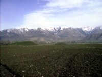
Karkara
The Issyk Kul Basin is ringed by mountains, (the Kungei Ala Too to the North and Terskey Ala Too to the South – the Sunny and Shady Mountains respectively). The Eastern and Western approaches to the Basin are formed by the Karkara Valley (Black Crane) and Boom Gorge (Shoestring Gorge).
The generally held opinion is that the Karkara valley takes its name from the birds that rest here on their migration between Siberia and South Africa. There is, however, another theory that Karkar comes from a Turkish word and means “the people living in the snow” – the area is covered with abundant thick snow during winter.
The Karkara River rises about 60 kilometers Northeast of Karakol and flows Northwest before turning West and descending through a wide open plain, full of lush pastureland before entering the lake near the town of Tyup.
It is a long valley which straddles the Kyrgyz-Kazakh border. The border is not well marked, that is there are no fences and, according to many sources, herders from both sides, attracted by the pastures, bringing their flocks to graze here during the summer months … although I’m not sure that it’s quite as porous a border these days as it used to be.
The area has long been inhabited. There are Sak burial mounds dating from between third centuries BC and AD.
There is a story that associates Karkara with the birthplace of the legendary hero Manas. A sixteenth century manuscript says that Manas was descended from Kipchak Jakypov Karaka, (but in those days, the term Karkara referred to vast areas of mountain steppes between Lake Balkash and Irtysh, and several mountain ranges).
About twenty kilometers from the Kazakh border, at San Tash, (Counting Stones), there is another interesting mound; this one made of stones. It is unusual because there is no obvious source for the stones nearby.
There is a story that Tamerlane was marching his army to attack the Chinese over an unnamed pass in the Tien Shan mountains, and he ordered that whilst there in camp down at Lake Issyk Kul, each soldier should pick up a stone … here he commanded that they place the stone in the mound. On their return they were pich up a stone from the mound and return it to the lake. The invasion was a failure and he suffered a rare defeat and this mound commemorates the fallen in battle. In effect, they had built they had built their own memorial.
There is, however, another theory, that the stones were brought here to cover a mass burial site and the mound was created by archaeologists when their expedition uncovered the site … or perhaps by grave robbers.
Whichever theory is correct, the site provides a mysterious and moving experience.
The first Russians into the valley were the explorers Valikhanov and Semyenov, in 1857, who were hospitably received by the local Khan of the Bagu clan, Burambi Bekmuratov, before travelling on accompanied by local guides. From the jailoo, (high mountain meadow), the expedition rode up a steep trail passing high cliffs of light blue limestone. At the top of the pass the travelers were “blinded” by the spectacular views of the mountains … Semyenov wrote:
I spent three hours on the pass to admire the magnificent view, the likes of which can hardly be found anywhere else in the world, and to navigate the high orography in the Tien Shan mountain group, which local residents so aptly given the poetic name “Tengri-Tag” (“The range of spirits”), comparing these snowy peaks of the heavenly spirits, and crowned them with its grandeur and overwhelming giant – Khan-Tengri, which is, King of the heavenly spirits., hence the Chinese name of the whole mountain range of “Tien-Shan” (“Celestial Mountains”).
In Soviet times the valley was apparently known as “milk valley” because of the herds of dairy cattle which grazed here to serve the butter and cheese plant that was located near the San Tash Pass.
Each year, the nomads gather and hold a fair in the valley, the Chabana, where they trade livestock, pack animals, food and where people are recruited for expeditions. It is one of the most famous fairs in Central Asia and features in most, (if not all), the guide books … and we get asked if it is possible to arrange a visit to it. The problem is that the date is not fixed and, to be honest, I have yet to meet anyone who has actually attended it.
The Basharino border post, (often called Kegen after the nearest ton on the Kazakh side), about is pretty basic, consisting basically of a wagon in the valley and is open only during daylight hours, (9:00 am to 6:00 pm), in the summer months … and there’s often no stamp which can cause complications. It’s a little less than 100 kilometers from Tyup, and 30 from Kegen. The road is scenic but rough as it is not asphalt for about half of its length, covered in gravel for about 50 kilometers on the Kyrgyz side and 15 on the Kazakh side of the border.
Despite this, it was a popular crossing, especially for those coming from Almaty to the Eastern end of Lake Issyk Kul, Karakol and the peaks of the Eastern Tien Shan as it was shorter than travelling West to Bishkek and then traveling up to Karakol. After the 2010 revolution, however, the border was closed and the post only reopened in June 2013.
There are no Bureau de change facilities at the border so it is wise to change some money before crossing.
On the Kazakh side of the border there are a couple of side trips which are popular with visitors, the Charyn Canyon and Bartogai Reservoir.
In the valley, there are numerous yurts which can offer accommodation for tourists and a Camp with a helicopter pad used for ferrying climbers up to the mountains for ascents of Khan Tengri and Peak Pobeda.




 Bishkek