Kurgans – Ancient burials
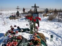
I am aware that there has been a somewhat depressing turn to the postcards recently, in that there have been quite few references to deaths and funerals.
I have mentioned several times that last year was the year of the “black tie”. It wasn’t just a case of the number of people that died in the turmoil that we experienced during the year, but a number of friends and acquaintances also passed away and, as a result, I visited the cemetery on a few too many occasions for my liking.
Yesterday involved yet another trip, but this time it was not because someone had just died but rather to mark the one year anniversary of his death. There is a tradition here, that as well as holding a wake, (called a “pamenka”), on the occasion of the funeral, the friends and relatives also gather on the ninth, the fortieth day and after a year, to mark the occasion and remember the deceased. Although this marks the end of the mourning process, there are other occasions when one visits the grave, on birthdays and anniversaries and on Roditelskiy Dehn, (the second Tuesday after Easter – Orthodox Easter, that is).
Roma was a close friend of mine who died suddenly a year ago, hence, yesterday’s visit to the cemetery.
At times like this, as well as remembering the deceased, one also thinks about the metaphysical questions of life and death. I suppose it’s natural but I won’t dwell on those here and now. However, as I was preparing for the visit, my mind wandered to the question of cemeteries. The graves are marked out in serried rows, marked by memorials, a surprising number of them in the form of cross.
How different it was in ancient times. We have, for example, an interesting and graphic account of the funeral of a Chieftain of the Volga Vikings. Yes, that’s right, The Volga Vikings. The Vikings not only launched seaborne raids to the West, from Scandinavia to the islands of Britain and Ireland, to Iceland, Greenland and even America, they also travelled overland, carrying their longboats over mountain passes and floated them down the Volga river. There was even a company of Vikings who formed the body guard for the Byzantine Emperor. One group encountered a diplomat from Samarkand who witnessed the funeral in question and wrote the account, which involved a lot of feasting and drinking, the gang rape of a girl selected to be a human sacrifice as well as the feature that we would probably recognize from our history lessons and the movies: the burning of a longboat.
Not all ancient people had such brutal ceremonies associated with the internment of a recently deceased leader. Most cultures seem to have buried their dead, rather than launching them on the waters in a fiery tomb, often under a huge mound of earth which rises above the surrounding terrain – a kurgan.
The word “kurgan” is derived from the ancient Turkic word for “castle” and is often used as part of a place name. However, it does not refers to a fortress or fortification, but rather to a large tumulus, (burial mound or barrow), where earth has been heaped over the burial chamber of a tomb. Within the burial chamber, at the heart of the kurgan, elite individuals would be buried with a variety of “grave goods” and sacrificial offerings, sometimes including horses and chariots.
Kurgans are found throughout the Eurasian continent, often extending in great chains for many kilometers along ridges and watersheds. They are characteristic of various Bronze Age peoples, and it is thought that their use spread from the Steppes of Asia to Europe in the third millennium BC.
It is thought that kurgans may have been located near the territorial boundaries of a clan or a family lands. Until recent times, the Kazaks and Kyrgyz buried their deceased only near the winter pastures – that is at lower altitudes rather than high in the mountains.
Kurgans have provided us with much information about civilizations that prospered in this area in ancient times. Often, nearby are also found the remains of ancient settlements, balbals and petroglyphs. Archaeologists have discovered many artifacts in excavations of kurgans. Perhaps the best known example in this part of Central Asia, was the Issyk Kurtgan. Although it was just over the Kungey Ala Too, to the South of Almaty in Kazakhstan, it gives a good indication of the peoples who occupied the region at that time.
It was discovered in 1969, it measured 60m in circumference and was 6m high. It has been dated to the 4th or 3rd century BC. Amongst the notable items discovered were:
- a skeleton of uncertain sex, in all probability an 18-year-old Sak (Scythian) prince or princess, (variously called the “golden man” or “golden princess”), which had been interred complete with warrior’s equipment, and and with rich funerary goods, including 4,000 gold ornaments. The “golden man” was adopted as one of the symbols of modern Kazakhstan – for example, a likeness of the “golden man” crowns the Independence Monument on the central square of Almaty.
- a silver cup bearing an inscription which offers us one of the few remaining examples of the ancient Scythian language.
These finds are on now display in Astana, the capital of Kazakhstan.
The Kurgans of Kyrgyzstan
Kyrgyzstan has a large number of tumuli, mainly in the Northern part of the country, along the Northern Branch of the Great Silk Road: around Lake Issyk Kul and along the valley of the Chui River – in the foothills of the Kyrgyz Range.
The greatest concentration is at Kok Bulak in the Issyk Kul oblast, to the north of the main Bishkek-Balykchi road, where there are over 250 barrows dating from between the 6th century BC to the 10th century AD. (There are also petroglyphs nearby, some of which date back to 2000 BC.)
There is a collection of some 70 kurgans, (which date from between the 6th century BC to the 9th century AD, some reaching 3 meters in height), a kilometer to the south of Kok Moinok, (in the Issyk Kul oblast, where the road to Naryn and Kochkor leaves the main Bishkek-Issyk Kul road), on the banks of the river Chu.
Near Kara Oi, to the West of Cholpon Ata – the main resort on the Northern shore of Lake Issyk Kul, is another collection of about 40 kurgans notable for the different sizes which, it is thought, denotes the variety of “occupants” ranging from clan elites to simple nomads.
The largest kurgan in Kyrgyzstan is at Darhan, a small village to the west of Kyzyl Suu in the Issyk Kul oblast. Known locally as Kara Dube, it is thought to be a royal burial site and dates from somewhere between the 6th and 4th centuries BC. It measures 100m in diameter and is 12m high.
Other sites where kurgans can be found in Kyrgyzstan are:
Ak Chii : Issyk Kul : About 2-3 kilometers outside the village are some balbals dating from between the 7th and 9th centuries.
Ak Sai : Issyk Kul : the village of Ak Sai lies on the Southern shore of Lake Issyk Kul. To the North East, on the left bank of the river is a burial mound, 40 meters long and 5 meters high, dating from 6th and 4th centuries BC.
Ala Bel : Issyk Kul :about three kilometers from the road from Ottuk to Kochkor, is a collection of about 20 barrows.
Ala Tash : Issyk Kul : To the South East of this village, on the southern shore of Lake Issyk Kul, archaeologists have unearthed the remains of a Silk Road settlement dating from between the 10th and 12th centuries – including some fortifications about 3m tall. The first excavations took place as long ago as 1884. There are also a number of Balbals in the neighbourhood dating from the 6th to the 9th centuries, and some petroglyphs from about 2000BC. There are also some burial mounds from the 3rd century BC to the 6th century AD.
Alchaluu : Chui : In this village at the foot of the mountains, South West of Kemin, are some ancient burial mounds.
Alexandrovka : Chui : To the West of Bishkek, are a number of burial mounds scattered about the farmland. These are the last resting places for some of the nobility of the ancient Sak and Usun tribes that settled in the Chui valley between the 7th century BC and the 3rd century AD.
Boz Barmak : Issyk Kul : At the extreme western end of the lake, south of Balykchi, lies the hill of Boz Barmak. On the slopes were found some stone-age implements dating back more than 100,000 years. There are also 8 burial mounds dating from the period of the Saks.
Chon Aryk : Chui : A small village, South of Bishkek, the barrows can be seem along the side of the road from Bishkek.
Chon Koi Suu : Issyk Kul : The valley lies between the villages of Baetova and Sary Oi, in the valley of the Chon Suu river, and petroglyphs have been found across an area of three square kilometres, dating from between 1000 BC and 1000 AD. They depict many animals that used to be native to the area and also pictures of daily life. The valley is also home to a series of burial mounds dating from the period of the Saks.
Chon Tash : Issyk Kul : to the South West of the village lie some burial mounds dating from between the 3rd century BC and the 3rd century AD.
Ichke Suu : Issyk Kul : To the East of this village in the Tyup region are some barrows, (burial mounds), dating from 1000 BC, and some more dating from between the 3rd century BC to the 3rd century AD.
Jele Debe : Issyk Kul : A small village near to Djety Oguz – unremarkable, except for the fact that it is the home of Tenti, who has been hunting with eagles since he was 12 years old. There are, however, some barrows, (burial mounds) here, dating from between the 7th to the 3rd centuries BC, laid out on a North-South axis. They measure between 40 to 60m in diameter and are 2-3m tall.
Kaindy : Chui : One of the valleys in the Kyrgyz Krebet. The town of Kaindy sits across the main road from Bishkek to Tashkent, and was important for a Sugar factory. High in the mountains above the town was an early gold mine. The road climbs gently into the mountains and though the valley housed a pioneer camp, the valley is rarely visited by foreigners. South of Kaindy lies the site of Ashpara – an ancient settlement dating from the 6th to 12th centuries. To the south lie some Royal Barrows – burial mounds dating from the 6th century BC to the 3rd century BC.
Kara Shaar : Issyk Kul : on the southern shore of Lake Issyk Kul, the site of some barrows, (burial mounds) dating from the 1st to 5th centuries.
Kara Talaa : Issyk Kul : the site of some burial mounds dating from the 5th to the 1st centuries BC.
Karakara : Issyk Kul : (= “Black Crane”) A high mountain valley at the extreme Eastern end of the Issyk Kul plain, on the border with Kazakhstan. The valley has a number of burial mounds dating from the Sak period.
Kashat : Issyk Kul : between the villages of Kashat and Temir there are some petroglyphs which date from the 2nd millennium BC to the 1st A.D., some barrows (burial mounds) about 4 m high and a stone building dating from about the 10th-12th centuries. (the Tash Koroo Temir) – .
Ken Suu : Issyk Kul :To the North and the West of the village lie burial mounds which date from between the 3rd century BC to the 3rd century AD.
Kermentu : Issyk Kul : At the Eastern end of lake Issyk Kul – near the modern village have been found the remains of a tenth century settlement. Also, nearby have been found a number of balbals and, to the south of the main road, a number of burial mounds which date from between the 7th and 3rd centuries BC, known as Ishen Ata, in the gorge of the same name.
Kichi Oruktu : Issyk Kul : To the South of the village lie a number of graves and barrows dating from between the 5th century BC and the 9th century AD.
Korumdu : Issyk Kul : A village to the East of Tyup – where the remains of a walled settlement dating from the 10th Century have been discovered. Nearby a number of burial mounds have been discovered which date from between the 3rd century BC and the 3rd century AD.
Kuturgy : Issyk Kul : To the South of the village lie a number of barrows, (burial mounds), dating from between the 7th and 4th centuries BC.
Maman : Issyk Kul : To the north of the villages of Uch Kainar and Maman are a number of burial mounds dating from the 6th to the 3rd centuries BC.
Ottuk : Issyk Kul : a small village at the south west corner of the lake – the site of some barrows, (burial mounds) dating from the 1st to 5th centuries.
Sak-Usan Kurgans : Chui : Located in the village of Alexandrovka, West of Bishkek, there are a number of burial mounds scattered about the farmland. These are the last resting places for some of the nobility of the ancient Sak and Usun tribes that settled in the Chui valley between the 7th century BC and the 3rd century AD.
Sari Kamish : Issyk Kul : in the centre of the village in the territory of the cemetery is the site of a Silk Road township dating from 10th to 12th centuries. Petroglyphs have also been found her dating from between the 2000 BC and 1000 AD, and a number of Sak burial mounds dating from the 7th century BC to the 2nd century AD.
Sari Tologoy : Issyk Kuk :about a kilometre West of the village, between the road and the river are a number of Sak burial mounds.
Saru : Issyk Kul : A village to the west of Kyzyl Suu where there are some ancient barrows (burial mounds) from 7th-6th centuries BC – measuring between 20-70 m in diameter and 2.5-8 m high. There are about 20 more, dating from between 7th-5th centuries BC, stretching along a North-South line about 8 km long, about 4-10km away on the Eastern bank of the river Djuuku. It is thought that they were constructed for the tribal elites of the Saks period.
Semiz Bel : Issyk Kul : to the west of the village of Tuura Suu at the western end of the Kongur Olon valley, which lies to the south of Lake Issyk Kul. A site of burial mounds and petroglyphs dating from the 6th to 8th centuries. There are also the remains of some building structures dating from the 10th to 12th centuries.
Shabdan : Chui : A village in the Chon Kemin valley. Nearby are some ancient barrows (burial mounds) dating from the 4th and 3rd century BC.
Tegirmenty : Chui : A village at the head of the Chon Kemin valley – there are some ancient barrows (burial mounds) nearby.
Temirovka : Issyk Kul : A village to the East of Cholpon Ata, with a number of ancient barrows (burial mounds).
Tuura Suu : Issyk Kul : There are two villages of this name in the Kongur Ulan valley on the southern shore of Lake Issyk Kul – one at the Western end of the valley and the other at the Eastern. A little to the south of Bokonbaeva – lies the larger of the two – at the Eastern end of the valley, where there are barrows (burial mounds) dating from the 6th to the 5th centuries BC.
Uch Kainar : Issyk Kul : To the north of the villages of Uch Kainar and Maman are a number of burial mounds dating from the 6th to the 3rd centuries BC.




 Bishkek
Strange … On the webpage for the film, (http://shortmovies2006.alotoffilms.com/australia/the-barrows.html),
“Related posts for The Barrows (2006) of other sites:
The Barrows (2006) on ianbek.kg”
I don’t see the connection … what on earth has the subject of Kurgans to do with a “Bonnie and Clyde” movie? …