Leading the World
An interesting map
I have a friend who “loves” maps … he’ll spend hours pouring over them, studying them in minute detail, saying the place names over and over to himself … whereas most of us would only occasionally use one as a reference work, to him – an atlas is a “good read”.
I once joked with him about this, and his comment in reply brought me up short … saying that he was surprised that I wasn’t also also an ardent fan of maps … because:
a) they are works of art … and
b) they are superb ways of conveying information, (it was before the days of that neologism - a “newly coined word or term” – the infographic) – knowing that I have an especial interest in statistics and statistical representation.
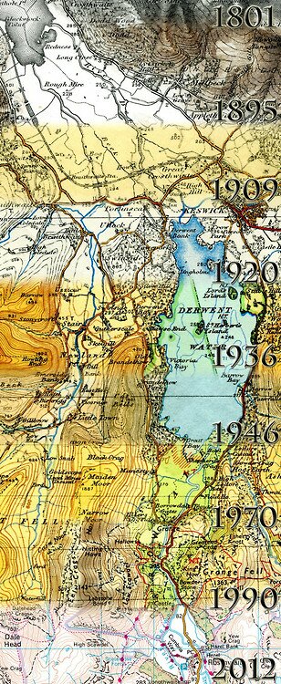
British Ordinance Survey Maps over the years (Source: the Ordinance Survey Twitter feed)
I had to admit that I could see his point … I always enjoyed mapwork lessons in Geography when I was at school … and I am impressed by the graphic ingenuity of the graphic designers who manage to create fascinatingly beautiful images which, as well as conveying an overall impression, are crammed with a mass of detail … like a Breughal painting … but
I felt, however, that he had missed out one more point:
c) I tend to have a “compulsive personality” … I don’t do things by halves but once I acquire an interest, (be it Batman or Star Trek, Shakespeare or Graham Green, computers … or Kyrgyzstan), I tend to be driven, throwing myself into it with enthusiasm and fascination … at least until something else comes along and replaces it.
It’s something I inherited from my mother who was an avid craftswoman – she would regularly take up a new craft, learn all she could on the techniques until she was satisfied that she had mastered all that she needed … and then moved to the next: knitting, crochet, lace making, embroidery, patchwork, glass engraving, embossing leather, jewelry making, and so on … the only thing I remember her taking up and then dropping was sketching.
I often think she would have loved it here in Kyrgyzstan with Shyrdaks, Ala Kiyiz, Saima, Kurak, Chiy, woodwork and leather work … it’s a real craftsman’s paradise.
I suppose it’s not surprising, therefore, that I “follow” a number number of feeds on different social media platforms, (Facebook, Twitter, Tumbler, Pinterest and so on), which specialize in posting interesting maps.
I don’t spend hours pouring over them, like my friend, but I do scan them to see if there is anything of particular interest.
Every now and again I see a post of the “Maps that will change the way you look at the world … ” type. The other day I was looking at one of them which had entries like:
- Places actually “discovered” by Europeans since the Age of exploration … by country … Russia leading the way in terms of square kilometers but Portugal far outstripping everyone else in terms of population;
- Wind patterns around the world and the distribution of hurricanes and cyclones;
- How humans spread around the globe – from Africa through the Eurasian land mass to all corners of the world;
- The tributaries of the Mississippi – which covers virtually the whole of the mid-West … but surprisingly little from the Southern states;
- Where in the modern world, slaves can still be found;
- The movement of the world’s economic “center of gravity” over the centuries of the “common era” … the 2014 AD years;
- The distribution of the naval power in the Pacific Ocean;
- A map of Europe showing the languages that people “tweet” in;
- What the continents will look like when the polar ice caps melt and sea levels rise.
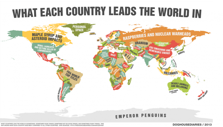
One that, initially, I passed by quickly, was “What each country leads the world in” …
A zoomable version is available here.
I say “initially” because on first glance whereas some of the maps drew on statistical data or mathematical data, this one seemed to be based on opinion, stereotypes and an attempt at humour. Consider the following examples:
- Canada: Maple Syrup and Asteroid impacts;
- Russia: Raspberries and Nuclear Warheads;
- The United States: Nobel Laureates and getting killed by lawnmowers;
- Uruguay: Eating Beef
- Cambodia: Long Alphabets;
- Myanmar: Speaking Burmese;
- Zaire: Pygmy Chimpanzees;
- Togo: Bad Driving
- Britain: Fascist Movements;
… and, I didn’t think Antarctica (Emperor Penguins) was a country …
… but then, when I thought about it, I decided that maybe there was a serious point here.
Anyway, I did what I suspect most people would do, and went to see what they claimed their own country led the world in … and the reference to Fascist Movements didn’t exactly fill me with confidence but when I went to look at Kyrgyzstan and saw that we lead the world in Walnut Forests. Now, that’s actually true, The Royal Woods of Southern Kyrgyzstan include the world’s largest relicts of Walnut stands … even though they probably didn’t originate here. They are not plantations, orchards or cultivated trees but wild Walnut trees growing naturally on the hills flanking the Ferghana Valley. The little community of Arslan Bob is a favourite stopover for travelers who want to see them … but the trees are to be found throughout the region.
To take another example, the country at the top of the map, Greenland, which was cited as the leading country in the world when it came to “Personal Space” … but then, Greenland does have the lowest population density in the world, (at 0.03 people per square kilometer).
Having spotted that, I went to have a look at some of the other claims … and, although I didn’t look at all of them, I could see some basis for the various claims … but, although you have to go looking for it, they, (Doghousediaries – the compilers/designers of the graphic), did cite their sources … you have to go looking the full list of references to the wikipedia pages they based the entries on.
I began to wonder what else could have chosen for Kyrgyzstan … my mind turned the question of mountains, glaciers, felt carpets … but I could only come up with:
- the Manas Epic – the worlds longest epic poem? – although some people claim this title belongs to The Mahabharata, at just 200,000 lines of verse it lags a little behind the Epic of Manas which is said to have about 500,000 lines;
- Heart Disease? – but according to World Health Rankings … we are actually in 3rd place when it comes to death rates per 100.000;
- the number of Prime Ministers, (at least since 1991)? – well, at least one politician here claims this;
- the number of unofficial road blocks, as people protest their cause? – I don’t know of any comparative statistics for this …but … well, it feels like that some times;
- the greatest improvement in the World Bank’s Doing Business Survey – well, it was a pretty impressive performance in 2012 … but …;
- the number of road accidents? – actually that was in just the CIS … in 2013
- …
.
Of course … not all of those are exactly positive … maybe it would be better to be like Tajikistan … which was one of those countries that had no entry … one of those countries that apparently doesn’t lead the world in anything …
.
I wonder what else Doghousediaries could have chosen … any suggestions?




 Bishkek