Batken Oblast
Tomorrow, the Batken Oblast celebrates its birthday … The administrative region was created on the 12th October 1999, out of the extreme South-Western parts of the existing Osh Oblast, (partly in response to incursions by armed militants of the Islamic Movement for Uzbekistan seeking to cross Kyrgyz territory between Tajikistan and Uzbekistan).
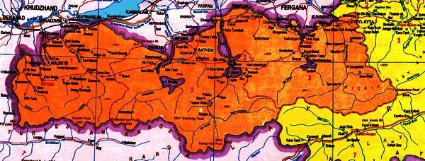
Batken oblast
Batken is located in the southwest of the Kyrgyz Republic, and consists of four mountainous regions, with altitudes ranging from 400 to 5621m asl.
It borders the Ferghana oblast of Uzbekistan to the north, the Sogd oblast of Tajikistan to the southwest and Osh oblast of Kyrgyzstan to the east.
There are a number enclaves – parts of other republics – contained in the territory:
- Belonging to Tajikistan: Vorukh and Kairagach
- Belonging to Uzbekistan: Sokh and Shakhimardan; and the tiny territories of Chong-Kara and Dzhangail located N of Sokh and NW of Shakhimardan respectively.
Statistics:
- Area: 16995 square kilometres -
-
Population: 380300 – according to the 2009 census – although there are some 428000 registered residents … the balance presumably working in other parts of Kyrgyzstan or as migrant workers abroad, (for example in Kazakhstan or Russia)
- the majority, just over three quarters, living in rural districts and the rest, almost a quarter, living in urban communities
- although there are something like 60 different nationalities represented, but most of them in very small numbers. The population is predominantly Kyrgyz – with just over three quarters of the total. Other nationalities include Uzbeks (almost 15% of the total) and Tajiks (just under 7% of the total).
- just over 40% are recorded as being in employment and about 1.5% are registered as unemployed. (Personally, I suspect those figures may be a little misleading as most of the people in the rural areas will count as agricultural workers and therefore considered to be self employed rather than unemployed).
Climate – The climate is continental: winters are cold and summers are hot. The average temperature is around +27C in June and about –3 in January. In the mountains, the climate is alpine with winter temperature going as low as – 40 C degrees. The average rainfall is about 200-500 mm.
Landscapes – Batken occupies part of the Ferghana Valley, the piedmont of the Turkestan and Alai ranges, and the river basins of Isfairam, Shakhimardan, Ak-Suu, Sokh, Isfara, Kara-Suu, and Leilek. The area can roughly be sub-divided into two types of geo-physical landscape.
- The Northern part is rolling, semi desert arid steppe and hills, dotted with irrigated, agricultural enclaves.
- The Southern part, along the Kyrgyz-Tajik border, are treeless ranges of Alai, Turkestan, subsidiary ranges of the Pamirs”.
Main Towns – Batken, Kyzyl Kia, Isfana and Sulukta.
There are also five “urban type settlements”, (a settlement with a population of at least 2000 that includes some economically significant facilities – such as industrial plants, railway stations or construction sites – or with a recreational potential – such as a resort), and almost 200 villages.
Most of the settlements in the oblast can be classified as “lowland” – i.e. below 1200m asl. The lowest village is at 410m and the highest settlement at 2040m.
Remoteness (measured in terms of distances from the Capital, oblast and other administrative centres) increases from East to West due the difficulties of road access – both in distance and time. The problems associated with travelling through the enclaves further enhance this aspect of life in Batken.
The region is not very well known – there is not a lot of information available, even in the Republic itself – and most tourists tend to come from within Kyrgyzstan itself, or the surrounding republics. There are a number of tour-bases around the oblast, (notably the “Pyramida-dolina” in the Batken region, Ak-Suu, and Ozgorush in the Leilak region, and Dugaba in the Kadamjaiski region) which have been host to a number of international mountaineering expeditions. There have also been attempts to develop skiing and caving in the region.
The Turkestan Mountains offer glaciers, spectacular scenery eroded by wind and ice and tremendous temperature changes created peaks such as Asan (4200m) and Iskander (5120m) that looks like a row of sharks teeth, surrounded by lush pastures, with a wide range of fauna and flora. The southern mountains offer excellent, but very difficult climbing with many sheer rock faces. Some of the more famous summits are Pyramid Peak (5,509 meters or 18,074 ft) and Peak Skalistiy (5,621 meters or 18,442 ft).
There are a number of sites of antiquity scattered throughout the oblast.
Among the places of interest in the oblast are:
Batken - The administrative centre of the oblast. Actually, it was granted the status of a city only in 2000, although a village has stood on this site since the early 20th century – which quickly grew in importance as it developed into the district centre. As such it has a number of regional offices and government buildings.
Situated on the crossroads from Isfara to Osh in the extreme south west of the country, it can serve as a base to explore the surrounding area.
In 2004 a new complex of new memorials were erected at the gates of the city depicting the legendary hero Manas on his charger Ak-Kula, Bakai his friend and counselor and some of the 40 warriors who accompanied him, old men, women and youths, his trusted dog Kumaik, his white falcon and hawk and other figures representing people and animals from the surrounding region. The monument was created by a local sculptor, Turgunbay Sadykov, and has similarities to that outside the Philharmonia in Bishkek. It is in the center of a park which, it is planned, will house various recreational facilities including a summer theater; a hall for chess, checkers and other games; an arena for kuresh wrestling (which is very popular in this region) and a large Chaihana (tea-house).
Aigul-Tash : A village and mountain about 20 kilometres from Batken – The village was established only in 1972 when it was planned to build a reservoir on the Sokh River. Several villages were threatened with flooding and people were to be re-settled. The houses of Aigul-Tash village were made of stone, but nowadays they are empty – the project was not been implemented. The mountain is named after a girl in a legend, the daughter of a Khan who ruled an area where paths of the Silk Road crossed. She loved the commander of the army, Kozulan, who perished whilst fighting invaders. His soldiers brought her his heart and she, grieving buried it and then threw herself off the top of a mountain. Where drops of her blood fell beautiful flowers grew and blossomed – Aiguil’s flowers.
Ak-Suu : The Ak-Suu tour camp is located at 5335 meters a.s.l. some 80 km from the regional centre near the Kara Suu river and has hosted a number of mountaineering expeditions.
Ak Teeter : Near the village archaeologists have discovered evidence of mine workings dating from between the 5th and 9th centuries – known as the Kan-i-Gut mine.
Andarkhan : Near the Hodka Bakirgan river, a number of burial sites and remains of ancient settlements have been discovered nearby that have yet to be dated. Also 1.5 km away, have been discovered the remains of the ancient settlement of Tortkul.
Aksuu and Karavshin Peaks : Two sharply pointed 5000m peaks along the watershed of the Turkestan Mountains.
Akturpak : near to the village of Alturpak in the Kadamjay district of Batken oblast, there is a cave said to be very beautiful with walls displaying a variety of colours, as if crystal. The air in the cave is considered to be for the treatment of bronchitis, asthma and allergies – although there is no actual scientific research to support this claim. The local people decided to build a sanatorium nearby for those seeking treatment utilising the power of this natural remedy with the help of local akims, deputies and local entrepreneurs. The cave has been fitted with electricity and water. The sanatorium, which is not yet complete, has a capacity for just 20 people – although plans exist to double this.
Beshkent : In the centre of the village, archaeologists have found evidence of an ancient settlement.
Chorku : On the outskirts of the village is Hodja Gor, a mound which dates from the Paeleoloical era.
Daroot Korgon : To the West of the village are the remains of a 19th century fortress.
Dugaba : The Dugaba mountaineering bas in the Parmir Altai mountains lies at an altitude of 2100 m on the slopes of the Alai spine., 31 km. From the centre of the Kadamjai region, in the gorge of the Dugaba river, surrounded by deciduous and pine woods (with large numbers of archa – spruce – trees). Beyond the base there are extensive mountain meadows, which extend up to the snowline.
Gandakush Pass : a remote mountain pass in the Parmir Alai.
Hodja Gair : To the West of the village lies some graves dating from between the 1st and 5th centuries. Nearby some ancient relics have been discovered.
Isfana : This town in the extreme South West of the country is the site of an ancient settlement dating from between the 14th and 15th centuries. It is the regional center for the Leilak region.
Jety Kopuroo :
Jubilenaya Cavern : In the mountains south of the Uzbek Sokh enclave, near the Tajik border.
Kan : The Kan Fortress stands above the village of Abkol on the Sokh River. It was an important fortification of the Kokand Khanate in the 17th century and is still reasonably well preserved. It is divided by a deep hollow into two distinct parts which were connected by a bridge. Where the bridge meets the larger of the two fortifications were two conical towers. The smaller of the two parts, nearer the mountains, may have been a pen for holding livestock, etc. In the courtyard is a stone engraved with images of animals and and men riding camels – perhaps depicting a connection with travelers along the Great Silk Road. This stone predates the fortress itself.
Kan-i-Gut : Eighteen kilometers from the settlement of Samarkandyk, in the Batken oblast, on the slopes of a spur of the Turkestan ridge of mountains, lies the mysterious and legendary cave of Kan-i-gut.
From as early as the 10th and 11th centuries silver and other minerals were extracted from the caves … and at one time the cave was known as the “Mine of Death”. In the days of the Kokhand Khanate, criminals sentenced to execution, political enemies of the authorities and others were sent here to work in the mines. They were turned loose in the labyrinth of caves, which stretches for over three kilometers, and if they returned without ore of the precious metals, they were either killed or sent back to look again. Once they entered the caves – there was no way to emerge again. Many invented tales to astound their goalers - and hopefully earn themselves a release – including stories about a sleeping camel with jewels as eyes, a mysterious green plant that grew underground, walls made of silver bricks, and terrible creatures which acted as guardians protecting the caves treasures. The mines are now all but exhausted.
In 1896 two Russian amateur geologists were sent to the explore the cave by the then governor of Turkestan. Their account of their visit includes a description of what they encountered. The expedition wasn’t exactly well equipped by modern standards with just one rope, some candles, a primitive lantern, a shovel and some smoked fish. They negotiated with some local shepherds who agreed to show them the caves – but warned them of the dangers of getting lost, or confused, in the labyrinthine maze of which the cave consisted. They were told stories of how a party of five once descended … never to return … their skeletons still adorning one of the cave’s galleries. The shepherds also told them of the ancient accounts of magical forces which protected the many treasures which lay within.
The explorers said that the entrance to the cave reminded them of a gothic temple, or cathedral. They proceeded onwards, into the darkness. Although remembering that many individuals had been lost in these caves before them, they carried on and penetrated deep into the system.
During the Soviet period, further explorations were carried out, including an expedition in 1920 which lasted some 20 days, and hich discovered a second entrance to the system. Several maps of the system were created … and various caverns were given picturesque names: “Red Water Pool”; Skeleton Hall; “Bridge of Sighs”; “Bottom of the second Precipice”; “Camel Grotto”; Dragon’s Labyrinth” … and so on.
In 1972, 1976 and1984 further expeditions took place, and although the mines may have been worked out the caves still managed to reveal many treasures. A horde of 23 square coins from the 18th and 19th centuries was discovered.
The caves have not yet revealed their full extent … although more 30km of tunnels have been explored, it is thought that many more remain to be discovered.
Kapchygay :(= Gorge, mountain valley in Kyrgyz.)
Between the villages of Frunze and Kyzyl Kiya, but in the foothills, there is a “stand of ancient man” – dating from about 25-20 thousand years BC.
Kairagach : On the left bank of the Hodka Bakirgan river, a grave holding 8 bodies has been discovered, which has yet to be dated.
Kara Bel : Eight km North-West from the village of Kara Bulak in the village of Jety Tepe is a burial site dating from the 1st century.
Kara Bulak : Not far from Batken is the burial site of Kara Bulak – in which were discovered silk clothes which date from the 4th to the 2nd centuries BC. Abdilas Maldybaev, (1906-1978) one of the first Kyrgyz composers and a singer (tenor), whose portrait features on the 1 som banknote – was born here.
The Karavshin Mountains : The mountains form a narrow east-west spine of granite, about 15 miles long, among the usual shale and limestone peaks of the Pamir Alai, on the border of Tajikistan, Uzbekistan and Kyrgyzstan. Sheer and massive rock formations cut by vertical cracks and to many people they are reminiscent of rocky canyons in America, Patagonia and elsewhere.
Rarely visited by locals or visitors alike, wild life reigns supreme in this area. The few human visitors that do descend on the area tend to be either local shepherds and herders bringing their animals to the lush green pastures; the occasional miner working the deposits of mica, tin or other minerals (during the early parts of the twentieth century – the mine works have now been abandoned); and mountaineers intent on exploring virgin territory, (not all of the peaks in the area have been conquered).
Climbers “discovered” the area during the Soviet period, in 1947. Foreign climbers didn’t make an appearance until much later – a group of Americans being amongst the first in 1973. In 1986 the Soviet Alpine Championship was held in the Ak Suu valley. Karavshin has now become an attractive destination for climbers from all over the world. Amongst the advantages that Karavshin enjoys over more established climbing venues are the relatively moderate altitude and climate. It is only at altitudes of 4000m that permanent glaciers and snowfields form. – what snow may fall tends to melt away quite quickly and the lower slopes are generally clear of snow.
The terrain on the Tajik side of the border is much more rugged, steep and barren than the gently rising valleys on the Kyrgyz side. These valleys, beneath the soaring peaks, also provide opportunities for trekking, as opposed to climbing..
However, access to the area is difficult – passing through enclaves.
Also, in the Soviet period cross border routes used to exist, and we understand some people still use them, however, it is not advisable … it is illegal to cross borders except at official crossing points, and the border areas have been the scene of several encounters between armed groups and security forces.
Katvan : A number of burial sites have been discovered nearby that have yet to be dated, and some cave paintings dating 10th, 12th, 15th and 16th centuries.
Kek Suu : In the mountains, near the border with Tajikistan are a number of petroglyphs
Kobo-Char-Korgon : Near the confluence of the rivers Katta Sai and Kur Sai, archaeologists have found the remains of an ancient settlement dating from the 10th to the 12th centuries.
Kozulan-Tash : A mountain named after the beloved of Aigul in an ancient legend – which stands opposite a mountain named after her.
Kurban Kul : A mountain lake in the Dugaba valley, which can be reached in a trek from the Dugaba mountaineering base.
Kyzyl Kiya : a city of some 44000 people founded in 1898 on the northeastern border of Batken oblast. Situated some 1058 meters a.s.l. it has a railway link that connects it to Uzbekistan, and beyond to other CIS countries. The area is predominantly agricultural and tobacco plays an important part in the local economy – the “Dubek” tobacco plant grows only in this region.
Leilak : The Leilak region of Batken is located in the most extreme south western corner of the country. The regional center is Isfana. According to legend, the region is named after the stork (“ilek-ilek”) which lives here for a while on its migratory journey. The area is renowned for its carpets with their distinctive patterns and colourings. The Kyrgyz politician Iskhak Razzakov, First Secretary of the Communist Party from 1950 to 1961, was born in the village of Khursan in the region. It is said that the legendary hero Manas was buried in a cave in the area – and that the mausoleum in Talas was a deliberate ruse by his wife, Kanykei, to deceive his enemies and potential grave robbers from despoiling his actual final resting place.
Lumbur : some 6-7 km to the west of the village in the Sokh river basin, are the remains of a bronze age settlement.
Ochna : Ancient stone implements have been found in the village.
Parlmyan : Near the village, in the basin of the river Isfana Sai, some relics dating from the Paleolithic age have been discovered.
Pyramid-dolina : At an altitude of 5510m a.s.l. near Gerevshin – the camp has been host to several international climbing expeditions.
Sol Unkur Caves : To the East of the Sokh enclave, including some memorials dating from the Mesolithic era.
Tortkul : Some 1.5 km to the East of the reservoir there is a burial site dating from between the 1st-5th centuries.
Trym Pass : a remote mountain pass in the Parmir Alai.
Tuura Tash : At the southern end of the village of Bujum lie a burial site which date from between the 2nd century BC and the 3rd century AD.
Turkestan Range : Glaciers, spectacular scenery eroded by wind and ice and tremendous temperature changes created peaks such as Asan (4200m) and Iskander (5120m) that look like a row of sharks teeth, surrounded by lush pastures, with a wide range of fauna and flora.
Travel:
A number of governments advised against travel to this region following the incursions which led to the formation of the oblast.
The biggest problem facing potential visitors, however, is the fact that the road between Osh and Batken crosses the enclaves, requiring a double-entry Kyrgyz visa and an Uzbek transit visa, although it is possible to take an unmetalled road around the enclaves. There are, however, some flights between Bishkek and both Batken and Isfana.




 Bishkek