Talas
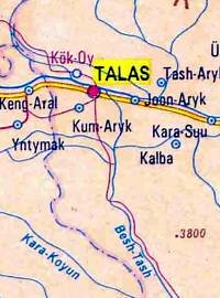
Talas
Talas is a town in a valley of the same name … and the administrative center of the oblast, which also shares the name.
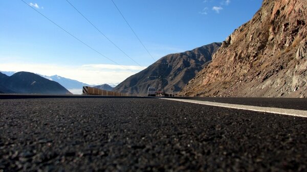
It is cut off from the rest of Kyrgyzstan by the mountain ranges and the “easiest” route is via Kazakhstan – involving the need for a transit visa. It is, however, possible to reach the valley by following the Tuu Ashu pass and then turning North off the main Bishkek-Osh road after skirting the Suusamyr Plain and crossing the Otmok Pass, (3330m asl).
For the record: The Talas oblast occupies the north-western part of the Kyrgyz Republic on the border with Kazakhstan and Uzbekistan. It also shares borders with the Kyrgyz oblasts of Chui and Djalal Abad. It is an area of Kyrgyzstan not often frequented by Western tourists – but has much to offer. Known as the motherland of the legendary Kyrgyz hero, Manas, there are many places associated with him. In the east of the oblast is the “road” said to have been traveled by Genghis Khan and where one of his wives is said to be buried.
Statistics:
Area – 11,446 square kilometers
Population – 210,000
Climate – A long valley, protected by mountains, Talas enjoys a milder climate although temperatures can rise upto 40C in the summer months of June and July.
Landscapes – Talas oblast is centered on a long, pastoral, valley – but still, over 80% of the oblast is mountains.
Reserves – The Besh Tash State Park lies13 km from the city of Talas, established in 1996 with 32411 hectares stretching some 30 km up the valley of the Besh Tash River.
Main Towns – Talas, Sheker
Places to visit – Talas and the nearby Manas Gumbez and Museum, the Besh Tash State Park; There are several sites where petroglyphs can be found; Sheker is the birthplace of the author Chingiz Aitmatov; and Kuporo Bazaar in the east of the valley offers spectacular scenery and several trekking routes; The “Cup of Immortality” at the remote Taldy Bulak.
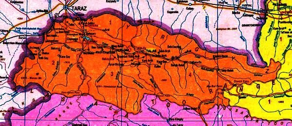
The Talas Oblast
This is known as the Land of Manas, reputedly it is the birthplace of the legendary hero, and has his mausoleum a few kilometres outside the city itself. There are a number of other mausoleums in the Talas valley – many of them seem to be modeled on this one.
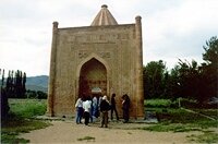
The Manas Gumbez
There are two different traditions relating to the origin of the gumbez, (or mausoleum). One says that his son Semetei carried the body here (to the village of Ahhyrtash, near the mouth of the Kenkol river, and built the mausoleum here for him. The other says that it was built by his wife, Kanykei, and his friend and counselor, Bakai – and that to prevent despoliation by his enemies they placed an inscription over the door that it was the mausoleum of a young girl.
It appears to have been built in 1343 AD, and is typical of the type of mausoleum that was built throughout Central Asia for centuries. It is not particularly large, measuring 4.38m by 4.48m. Built of baked bricks and clay mortar and is capped by a 16-sided pyramid. The entrance arch is framed between pillars and decorated with terracotta tiles. There are carved decorations – geometric patters such as 8 pointed stars and circles.
It features on the reverse of the 20 som note. The brickwork shows signs of complex decoration.

View from the mound
In the grounds of the mausoleum is a museum dedicated to the story of the epic and built as part of the Manas 100 celebrations in 1995. It is overshadowed by a mound, which was used as a lookout post by the sentinels whose duty it was to protect the valley. Archaeologists have made some interesting discoveries here and it appears that the mound may well be man-made – which, if true, is no mean feat. There are other signs of ancient fortifications at the site.
This area marked the greatest extent of the Chinese empire – as in 751 the Chinese army was defeated by an Arab, Kyrgyz and Tibetan combined force at the Battle of Talas. For some time, China had been under the T’ang dynasty – and they had succeeded in recovering lands that had been previously lost and stabilized the position on the Tibetan border. In the 740’s they gained control over Kabul and Kashmir. As they moved North and West, their forces under the Kao Hsien-chih (who led the army to victory in Gilgit and the Ferghana) they encountered the combined army and were defeated in the only battle between Arab and Chinese forces. The battle actually took place on the banks of the river Talas nearer the city of Taraz (Djambul) in Kazakhstan. It was more than just a military defeat for the Chinese, however, because amongst the prisoners rounded up after the battle were many experts in the manufacture of paper and silk – two closely guarded secrets by the Chinese – and their secrets soon found their way Westward to Europe. The Arabs were also well placed to extend the influence of Islam throughout Central Asia – and along the Silk Road, even if they didn’t pursue the Chinese back into China.
In about 1275 Nestorian missionary, Rabban Sauma, traveled West along the Silk Road, and eventually met with many important dignitaries. At Talas, in North Western Kyrgyzstan, he met with Kjaidu Khan, cousin of the great Kublai Khan. In Europe he visited the Vatican, and met with the English king Edward I in Bordeaux, France.
An atlas drawn up by Abraham Crescas in Palma de Majorca, in Catalonia, in 1375-77 contains a map of Kyrgyzstan, which depicts Issyk Kul and cites the cities of Jerusalem and Talas as “holy cities” for the Jews.
The area has been settled since about the 9th century, but when the Russians seized the settlement in 1864, it was little than a village. The modern town was founded in 1877, as the village of Dmitrovskoye. At first there were about 100 houses built the settlers, who were mainly engaged in agriculture. The most significant building was a church built of brick in the 1920’s.
There is a picturesque wooded park in the centre of the town, on the banks of the river and a large main square.
In the neighbourhood are some good examples of rock drawings and petroglyphs. Not far (about 20 km) to the north-east of the city are three sites : Kulan Sai, Terek Sai and Kurgan Tash.
To the south of Talas, lies the valley of Besh Tash (=”five stones”). This name originates from the five narrow, tall stones standing in the upper part of the park. There is a legend connected to these stones that tells about five robbers who lived in these mountains and robbed everybody who passed nearby. Once they robbed a nun and she damned them, so they turned into stones. The stones are still standing in a line. Locals say that ancestors put them this way. Probably it was the site of ancient sun worshipers… But who knows? The road climbs slowly at first and follows the Besh Tash river to a height of 2997 meters a.s.l., where there are some mountain lakes. Constantly changing, wild, spectacular mountain scenery and the fact that you are unlikely to meet other foreigners make this an interesting venue for either a day trip out of Talas, or as a base for a longer camping/trekking expedition.
The region also boasts the birthplace of the best known modern Kyrgyz author – Chinghiz Aitmatov – in Sheker, a small village near the Uzbek border.
The artist Theodore Hertzen, who is famous for his lithographs illustrating the Manas epic, was born in 1935 in the village of Ak Dobo in Leninopole, (currently known as Bakai Ata), where there is a small museum dedicated to his life and work.




 Bishkek