Ferghana Valley
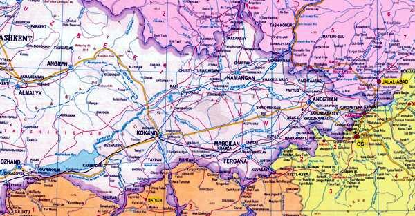
The Ferghana Valley
In recent weeks, the region known as the Ferghana Valley has been much in the news.
For the record: The fertile Feghana Valley is about 300 kilmeters long and 170 kilometers wide and is divided between three neighbouring Central Asian states, (Uzbekistan, Tadjikistan and Kyrgyzstan), and comprises the flood plain of the Syr Darya River, surrounded on three sides by massive mountain ranges: the Chatkal range of the Tien Shan; the Ferghana and the Pamir-Alai. However, because the mountains stand back so far from the flat bowl that forms the floor of the valley, many visitors are left wondering “where is the valley?”
The majority of the valley lies in Uzbekistan and, indeed, it is sometimes referred to as the “heart of Uzbekistan”; the Ferghana valley is home to a third of the country’s population and it is the most densely populated area in Central Asia).
The valley lies at heights that vary between 300 and 1000 meters a.s.l. At the entrance of the valley, known as the “Bekabadskiye Gate” is Khodjent (now in Tajikistan) – reputed to be the last outpost established by Alexander the Great on his campaigns across the region and named: “Alexandria the Furthest”.
The Ancient Chinese knew of the valley as the State of Davan – a rich land famous for agriculture, craftsmanship with about 70 large towns. The region was famous for its fruits - especially its wines – and sheep were also an important part of the local economy.
It was also the home of the Ferghana horses, (or the “Celestial Horses”), which were long sought after for their size, speed, strength and resilience.
It was also a center for the Basmachi rebellion which resisted Soviet domination.
The current borders were carved out in the 1920’s and seem very strange to the modern eye – with a number of enclaves created which are completely surrounded by the land of neighbouring republics. There are many stories about how Stalin sought to control the various by a policy of “divide and rule” –others about how the border was subject to intense negotiations between local politicians – and even how one enclave was won, (or lost), in a game of cards. The border is still a contentious issue and negotiations between the newly independent republics to delineate the border are still ongoing to this very day.
In terms of travelling the Silk Road, the opening of the Irkeshtam Pass means that it is now possible to travel from the ancient cities of Uzbekistan to Kashgar along the shorter, more direct, route. This does mean, of course, missing out on some of the magnificent mountain scenery that Kyrgyzstan has to offer.
The road from Tashkent used to be via Khodjent – as the railway currently goes – but in the 1950’s Soviet Engineers blasted a shorter route – including several tunnels – over a spur of the Chatkal mountain range – over the 2268m Kamchik pass – which in later years proved fortuitous as Khodjent now lies in the neighbouring republic of Tajikistan, The journey by road lasts about 4-5 hours.
Osh is by far the biggest population center in he valley – and the Dostuk crossing, just North of the city, is the only border crossing point available for foreigners to use. In Kyrgyzstan it also contains the cities of Uzgen and Djalal Abad as well as the Walnut groves of Arslan Bob. In Uzbekistan itself there are a number of other major settlements:
Andijan is the first major settlement encountered after crossing the border from Osh into Uzbekistan.
Originally a small village, it rose in the 13th century to be the capital of the region – a status it held for three centuries – it is one of the more ancient cities of Uzbekistan. Owing much of its prominence to its position on the Great Silk Road and in some ancient arab texts it is known as a “shopping center. Indeed, some people claim that it takes its name from a Silk Road caravanserai – but a prosaic explanation is that it is named after one of the Uzbek clans.
The city is surrounded by hills and high mountains.
It was the birthplace of Babur, the great-great-great grandson of Tamerlane, who having lost his own kingdom, went on to found the Mogul dynasty in India. In his memoirs, Babur notes that grain and fruits were abundant – he says in particular that the grapes and melons were excellent – and also birds and “beasts” for hunting. He describes the fortress, which – in the region – was superseded in size only by that of Samarkand, and lay to the South of the city, surrounded by a moat. He is critical of the “air” in the city, which he says was “unwholesome” and gave rise to fevers amongst the population.
It finally lost its status to the Khanate of Kokand, and later fell to the Russians in 1876, but only after having fought off a first assault which cost the attackers dearly. Most of the ancient town was destroyed in an earthquake in 1902. Now it is mainly a industrial center based on the cotton industry developed in Soviet times, but it also hoe to the Korean Daewoo Car factory.
Sights include the bazaar; the Babur Literary Museum – and the Babur Memorial Park; the Juma Madrassah and Mosque – the largest in the Ferghana valley, dating from the 14th century; the regional museum and the Navoi park.
The city of Ferghana is located at an altitude of 580m. above sea level, covering some 70 square kilometers in the south of the valley. It is the regional center and, with a population of about 320,000 is the third largest town in the valley.
Ferghana is the youngest of the regions towns, dating from the dissolution of the Khokand Khanate in 1877 and was originally known as New Margilan (after the ancient center of the silk trade, 20km away). The first Russian Governor General was the famous general M.D. Skobelev – and Ferghana, like most of the towns in the valley was the home of a large military base. Construction projects included the Governor’s mansion, a drama theater, a hospital (later the home of the deputy governor), a military barracks and a school (which later became a University).
As with Pishkek, (modern day Bishkek), the Russian authorities paid special attention into turning the town into a “garden city” - and with its wide tree-lined streets and parks it rivals Bishkek for the title of “the greenest city in Central Asia”.
Ferghana is often used by travelers as a stop-over or a center from which to explore the valley Sights in the town include:
- the bazaar;
- the Al Ferghani Park, (named after a 9th century astronomer born in the region);
- the Regional Theater and
- the Museum of local studies.
- Because it is a modern settlement, there are no ancient buildings or memorials, but the nearby landscape is attractive – and in the nearby lush, green, Altyaskaryskaya valley there are several mineral springs around which a sanatoria was built.
Kokand is one of the ancient cities of Uzbekistan, about 100 kilometers from Fergahana at the Western end of the Ferghana valley. It lies at an altitude of 405 meters above sea level. The city occupies about 65 square kilometers and has a population of about 180,000.
The name of the town is variously defined as “city of the boar” or “city of winds”.
It is not known who founded the city, or when, although it is known that in the 1st century BC, a number of small settlements existed here, which formed the basis of the lager town. The first written references to the town date from the 10th century. The Silk Road played an important part in the development of the town – and large caravans stopped here en route to/from India and China. It is known that the town was destroyed by the Mongols as they swept through the region in the 13th Century.
Although a young town compared to some of it’s neighbours, the modern town grew up around a fort, constructed in 1732 – and in 1740 it became the capital of the powerful Kokand Khanate in the 18th and 19th centuries. The Khanate stretched throughout the Ferghana valley and North to Tashkent and the Kazakh steppes – and South covering parts of Tadjikistan and even China. It played a role in the machinations of the “Great Game”.
At one time the city was recognized as a great center of learning with 35 medrasses and with over 300 mosques, it served as the religious center of the Ferghana valley. It later went into decline, losing much of its territory, and became a vassal state of the Russian Empire – until finally it was eventually subsumed.
In 1918 it served as capital for a short-lived “Muslim Provincial Government of Autonomous Turkestan” – which led to the sacking of the town by the forces of the Tashkent Soviet.
Sights in the city include:
- Khundayar Khan’s palace – covering over 4 hectares and constructed by craftsmen from all over Central Asia. At it’s height the complex comprised some 7 smaller palaces containing 119 separate rooms, all surrounded by a pair of 3m. high walls – but now only 2 courtyards and 19 rooms remain – decorated with bright colours, geometric patters and quotations from the Koran - and a large mosque;
- the Juma Mosque constructed by the Khan Umarhana in 1800 – supported by 98 wooden columns, with a 22m. high minaret topped by a dome;
- Khamza Museum; the Narbutabev and Dasturkhanchi madrassahs;
- the “Royal” cemetery containing several mausoleums of some the 29 Kokand rulers such as Dahma and Shahom, and Modori – the mother of one of the Khans – which is a fine example of islamic architecture with a classical blue tiled dome;
- The Norbutabi and Emir Medresses. The Norbutabi medrassah was one the largest in Kokand, and since Independence it has reopened and now has about 80 students enrolled;
- a number of Russian buildings dating from the turn of the 20th century and
- the Kaidarov workshop.
Although there is an airport – there are few places that offer accommodation and one of the companies with which we work in Uzbekistan says simply that “there are no hotels in Kokand”.
The small town of Margilan, a short drive from both Kokand and Ferghana, is the center of Uzbekistan’s silk producing industry, where the art of spinning and winding and dyeing and weaving silk by hand is till practiced. Today’s looms do not differ much from the ones on display at the Andijan museum. Over a thousand years of producing silk have shaped the “Ikat” style for which Margilan is renowned.
Located at an altitude of 475m. above sea level, it covers about 50 square kilometers and is home to a population of about 165,000.
It is one of the most ancient of the cities in the Ferghana valley. The first written records of the city date from the 9th/10th centuries – as well as references in early arab chronicles.
In his memoirs, Babur, notes that the region was particularly renowned for pomegranates and apricots. He describes how the locals would remove the stone from the apricot and replace it with an almond - after which the fruit would then be dried. He also mentions hunting – particularly for deer.
The town is also associated with a national dish – Murginon - based on ingredients such as chicken and bread, which local residents are supposed to have served up to Alexander the Great.
Despite the age of the city, there are not many monuments or ancient buildings … the most notable are:
- the Chakar mosque, and
- the Said Ahmad Hodja mederesse with its painted ceiling.
Namangan is a large, sprawling city – the third largest in all of Uzbekistan, although at the beginning of the 20th century it was the second largest.
Situated near the confluence of the Naryn and Kara Darya rivers, it takes its name after the nearby salt mines (“namak kan”). It is, true to a long tradition, one of the Islamic centers in this secular country.
Sights in the town include:
- the Natural History Museum;
- the Mullah Kyrgyz madrassah in the centre of the town – it has an unusual plan, forced upon the builders by the lay of the land;
- the Atavalikhonture mosque – built at the beginning of th 20th century;
- the Mullah Bozor Akhun mosque;
- the Khodjamni mausoleum from the 18th Century and
- the Babarakhim Mashrab Namangani museum.
In the surrounding environs are the ruins of the ancient settlement of Aksiketh – 25km to the Southwest; the site of the Silk Road center of Pap – which is notable for recent discoveries of graves with reed bound sarcophagi; the even older Silk Road center of Chust; Uchkurgan – famous for it’s lively bazaar; and Kasansay – once a fort from which the valley was controlled, with an impressive mosque.
About 50 kilometres from the town of Fergana, near to the Kyrgyz border, is the small town of Rishtan. It is also known as Rishdon.
A predominantly Tajik town, the citizens of Rishtan have been renowned for their ceramics for over 800 years. The secrets of producing ceramics from the local red clay and the glaze (“ishkor“) manufactured from the natural mineral dyes and ashes of the mountain herbs have been passed down through generations of craftsmen. ”Lyagan“, (Large shallow dishes), ”shokosa“, (bowls), pots for water and vessels for milk, are all decorated with characteristic, traditional, ornamentation in turquoise, azure, green and cobalt, on a white background. They are easily recognized worldwide and examples have been featured in numerous international exhibitions, museum displays, and private collections.
The enclave of Shahimardan is 90 sq.km of Uzbekistan, surrounded by Kyrgyz territory, located in a gorge in the Alai Mountains, 55 kilometres south of the Uzbek city of Fergana at an altitude of 1500m. above sea level.
Set in the Alai range of mountains, it is bordered on two sides by the mountain rivers Ok Suu and Kok Suu which at their confluence become the Shahimardan Sai River. The road from Ferghana crosses the river some seven times.
The enclave is traditionally connected with Hazrata Ata - the fourth caliph and son-in-law of the prophet Muhammed. The tradition states that when he came to Central Asia he settled in Shahimardan and it is identified as one of the seven possible locations for his grave. In the 1920′s there was a mosque and mausoleum in Shahimardan called Hazrata Ata – which was destroyed by the Soviets and then reconstructed after Uzbek independence.
At one time the village was known as Hamza-abad in honour of the poet and founder of Uzbek dramatic arts – Hamzy Hakim-zade Niyazin. In the 1960s a museum and mausoleum were erected in his honour.
Seven kilometers to the South-east is Lake Kulikubbon, (Blue Lake), which was formed as the result of a series of earthquakes in 1766. The lake is 1724m. above sea level and measures 170m long, 60m wide and between 5 to 10m deep.
It was well-known during Soviet times as a holiday destination for Uzbek and Kyrgyz party bosses, and is now a popular retreat for citizens of both countries who visit it’s mountain lakes and take in the cool mountain air and picturesque scenery.
Accounts of how the region became an Uzbek enclave vary. One account has it that the territory was lost by a Kyrgyz official in a card game with an Uzbek colleague. According to Kyrgyz politicians, “No agreements were concluded” and “the documentation clearly shows it to be part of Kyrgyzstan.”, and “there was no transfer of Shakhimardan to Uzbekistan by Kyrgyzstan, either under lease or any other way.” The reaction of the Uzbeks has been to refer to a time before the state of Kyrgyzstan existed – when the land was subject to the Kokand Khanate – and whilst admitting that the Soviet authorities “made national and territorial divisions very arbitrarily”, are opposed to handing the territory over to it’s neighbour.




 Bishkek