Kemin Earthquake – 1911
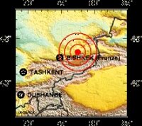
One of the major earthquakes of the last century
Sometimes it seems odd that disasters always seem to strike around the Christmas New Year period.
For most of the world it was January 3rd, 1911 – but here in Kyrgyzstan they still kept to the Julian Calendar, so it was December 22nd, 1910.
In Kemin, in Northern Kyrgyzstan, an earthquake struck. Although this is a seismically active zone and earthquakes are not uncommon, with a magnitude of at least 7.7, (the USGS - United States Geological Service, records it as being of Magnitude 7.8 and another source puts it at 8.2), it was pretty strong and according to source it was probably one of the strongest to ever strike at the center of a continent.
For the record: According to the list of “selected earthquakes of general historic interest“, compiled by the USGS, it comes in at the 121st strongest earthquake … although 7.8 earthquakes start at the 99th position.
It was so strong that it resulted in fault shifting along an extensive 200 kilometers in six different sections in the valleys of Chon Kemin, Chilik and Chon Aksu, (the land shifting by as much as a meter in places), and destroyed more almost 800 buildings, in Almaty, Kazakhstan, the other side of the Kungei Ala Too Mountains, (which was almost the whole of the city at that time). People recorded hanging objects swinging in cities more than 1,000 kilometers, (that’s 625 miles), away in Kazakhstan and Russia.
For the record: The Tien Shan mountains form part of a deformation of the earth’s crust resulting from the collision between the Indian and the Eurasian plates. In the region around Lake Issyk Kul there is a mix of “thrusting” and “strike slip” movements. The basin is bordered north and south by opposing thrust faults and the Chon Kemin-Chilik fault, along a valley to the North of the basin, there is a strike slip fault.
One of the effects of the earthquake was the creation of new lakes in some places by damming rivers and diverting water flows.
Given the scale of the earthquake, we are told that the number of casualties was relatively low because it struck in a mountainous area where, fortunately, the locals in the immediate vicinity mostly lived in yurts,( which are much more resistant to damage from earthquakes and, even if they do collapse … and therefore not likely to result in deaths or serious injuries). All the same, almost 50oo yurts were destroyed along with over a thousand buildings … most of the casualties, (over 450 deaths, almost 750 injured and almost 13000 head of livestock were lost), and the damage occurred as a result of landslides.
Landslides, rockslides, avalanches, debris flows and soil “dislocations’ occurred over a wide area, covering something like 10,000 square kilometers. The two worst landslides occurred in Kaindy, in the lower Chon Kemin valley, (where some 15,000,000 cubic meters of limestone rocks buried a group of yurts and killed 38 people), and Ananevo, (where another 15,000,000 cubic meters of rock, this time weathered granite, fell creating a 250m high backscarp – slope – which is still visible).
We have a fair amount of information about the earthquake because it was documented within just a few months by an expedition led by Bogdanovitch. There have also been two other research projects, but Bogdanovitch’s report provides the most immediate data.
He showed that this was part of a long sequence of earthquakes – finding evidence of maybe four or five previous strong earthquakes. A photograph taken by the expedition also provides evidence of a “delayed” effect of the earthquake, a debris flow formed by the collapse of some 20,000,000 cubic meters of glacial moraine, advancing on the plain below as a mudflow supporting large granite boulders, washing out the valley bottom, stripping trees along the way and partly damming the valley, As it is not to be seen in the photograph, it is argued, it must have taken place some months, (or even years), later.




 Bishkek