At Bashi
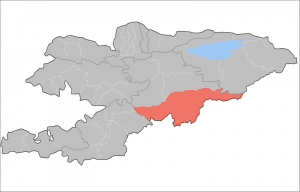
The At Bashi Region
A few years ago, the CBT guidebook to Kyrgyzstan stated: “If Kyrgyzstan feels like the far side of the world, the end of the line, then At Bashy feels like the last stop“.
According to official statistics, parts of the At Bashi region are the “remotest” in Kyrgyzstan. This conclusion is drawn from an index which is based on distance from the capital, and other centers of local administration, (oblast, rayon, ayil-kenesh), that gives a value of between 1.0 (for easily accessible places) to 1.75 (the least accessible places). The highest value for the country is 1.75 – and it’s in the At Bashi region.
At Bashi gives its name to:
- the village of At Bashi in the Naryn Province of Kyrgyzstan, about 40km to the southwest of Naryn – just off the main highway to the Torugart Pass and China. Indeed, At Bashi is the last sizable settlement before the Chinese border;
- the At Bashi administrative district, of which the village is the administrative center;
- the At-Bashi Range on the Eastern flanks of the valley extends 100km to the south, to Lake Chatyr-Kul;
- the At-Bashi River which carves out the At Bashi valley, which rises in the east and then runs northwest through a gorge in the Baybiche-Too range to join the Naryn River near Dostuk. As of 2009 it had a population of 10,764.
The village of At Bashi stands on the site of settlements that date from the 8th to 14th centuries.
It is a small center and serves as a departure for trips into the nearby mountains where there are yurts in the jailoo, and the northern entrance to the Ak Sai valley on the other side of the mountain range and in the border zone with China … and particularly the picturesque Kol Suu Lake.
The village has a relatively large local cinema – built in 1970 and seating 350. For several years it won awards as the best cinema in the country. In the last ten years or so it has fallen into some disrepair and needs considerable sums for reconstruction.
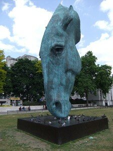
The Marble Arch Horses Head
One of the most recent “attractions” is a large statue of a Horses Head, apparently grazing off the ground on which is stands. Paid for by a local deputy it is based on a statue by erected in Marble Arch, in London.
The monument symbolizing grace and prosperity, made of Turkish material similar to bronze . It measures 11 meters in height, and is used as the local “kilometer zero”, with distances to nearby villages measure from it. In addition, around the monument are depictions of other animals living in the area.
At Bashi is Kyrgyz for “Horse’s Head” and a picturesque Kyrgyz story tells how the town got its name. A herder who had sold his cattle in the Andijan region (now in Uzbekistan) and on his return, exhausted, he settled down for the night at a place called Jailoo (= “pasture”) and turned his horse free. The horse wandered and fed at a place called Arpa (= “barley”). When the man tried to coral the horse the next day it ran away. He chased it and when he caught it he killed it and cooked its meat. He left the head behind and called the place At-Bashi (= “Horses head”). He ate the meat along his journey and called the place where he had his last meal from the carcass Naryn - which was the name of the dish he had cooked – a sort of soup with finely cut meat. If you find these places on the map you will see that they are quite far apart – the man went a long way to sell his cattle and chased the horse for quite a distance!
Nearby ruins of a small citadel at Kara-Suu dating from the 10th or 12th century.
Over the picturesque wooden bridge lies the village of Acha Kaindy – which was home to the craftswoman Janyl Alibekova who continued the age-old tradition of making felt carpets (shyrdaks and ala kiyiz) into which she creatively incorporated national motifs. As history would have it, after the break-up of the Soviet Union, and in a period of general economic decline, drew on her own and local resources and traditional techniques rather than relying on government assistance and adopting modern technological methods. She became famous in Europe, a star of the magazine Elle, and the director of her own workshop. Yet she didn’t change her lifestyle or her independent anti-patriarchal views. In 2002, she was the subject of a short, (14 minute) documentary film: Red Butterflies Where Two Springs Merge.
Further along the road to Torugart, (originally built in 1906), which runs southwest between the Baybache-Too and At-Bashi ranges, before turning south and then east to reach the pass and the border crossing to China, you can see the 5 meter high walls of the ancient settlement of Koshoi-Korgon. This is where the legendary Kyrgyz hero Manas is supposed to have buried his friend Koshoi – hence the name which means Koshoi’s grave.
Before the recent road reconstruction, just before the end of the asphalt and the start of a gravel road, the highway widened and this was designed to serve as an emergency military airstrip, built in the Soviet period to be used in the event of hostilities with China. Apparently it was never actually used and was poorly maintained and falling into disrepair.
Further on is the Tash-Rabat caravanserai – an architectural monument from the Middle Ages, set about 15 km off the main road up a side valley in the At Bashi mountains. It is about 125 km from Naryn, and 80 km from Torugart border post, at an altitude of 3530m.
The road continues around the end of the At-Bashi mountains, past Chatyr-Kul lake to the border post.




 Bishkek