Travel times and distance …
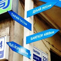
The distances may be right … but … do they point in the right direction?
We say that the shortest distance between two points is a straight line, (although the mathematicians and physicists tell us that things are not that simple). and we often use the phrase “as the crow flies”, (although birds rarely fly in straight lines).
One of the problems of Kyrgyzstan is that distances can be deceptive … although Kyrgyzstan is a small country, (measuring about 900 kilometers from east to west and 410 kilometers from north to south … with a total area of about 198,500 square kilometers), straight line distance between places make no allowances for the fact that roads meander to skirt the features of the landscape and have climb and descend the mountains that criss-cross the country.
This can be important as, for example, as the cost of transport may well depend upon the mileage (distance) – it is not unusual to be charged a rate per kilometer. (The rate will differ, for example, depending upon the type of vehicle.)
As one blogger has put it: “Travel in Kyrgyzstan is not always as easy as it may seem on a map.”
Sometimes we get inquiries where the prospective client has done some homework (for which they need to be praised!) and propose a route taking in the various places that they would like to visit … but, unfortunately, not all their suggestions are practical.
Sometimes the problem is simple … but hard to explain …
- maybe it’s because, on the map at least, it doesn’t look so bad … especially if the travelers say that they are ready to cover long distances in one day … but most of the roads in Kyrgyzstan are not motorways, freeways or autobahns … and it is easy to be deceived into thinking that the distance will give a way of estimating the time needed for a journey. The speed limit in built-up areas is 60 km/h, in the country it is 90 km/h – however this is fairly academic. Apart from the number of photo-stops, toilet-stops and so on … there is the vehicle to consider (… a bus can be a lot slower than a saloon car) and the quality of the road conditions can vary significantly. A distance of 250 km on one road may be covered easily in two and half hours – whereas 250 km on a different road, (or even a different day), may take most of the day. To make matters worse … many people tend to be optimistic and estimate a shorter time than is actually probable.
- maybe it’s just that that the road doesn’t exist … anymore. It did at one point (such as the A364 from Enilchek to Barskoon or over the Kyrgyz Range from Kegety to Kochkor. which still appear on many maps), but over the passage of time, maintenance has lapsed, bridges are down and it’s no longer accessible.
- maybe it’s because although the road exists, it’s only open for certain months of the year, (such as the road between Djalal Abad and Kazarman or connecting the Talas and Chatkal valleys).
Just to give you some idea , here is a table of distances between some of the main places of interest in the country, (although the actual distance may depend upon the actual route taken).
| Distances in Km | Bishkek | Cholpon | Djalal | Karakol | Naryn | Osh |
| ……….>>>>> From >>>>> | Ata | Abad | ||||
| vvvvv To vvvvv | ||||||
| Ala Archa | 40 | |||||
| Alamedin | 40 | |||||
| Almaty | 250 | (K) 380 | ||||
| … | (B) 700 | |||||
| Altyn Arashan | 440 | 40 | ||||
| Arslan Bob | 590 | 90 | 200 | |||
| At Bashi | 400 | 40 | ||||
| Avrora | 265 | 15 | 135 | |||
|
Balykchi
… |
180 | 70 | (N) 220 | 180 | ||
| (S) 270 | ||||||
| Barskoon | 330 | 120 | ||||
| Belagorka | 80 | |||||
| Bishkek … |
250 | 576 | (N) 400 | 360 | 700 | |
| (S) 450 | ||||||
| Bokonbaeva | 270 | 130 | ||||
|
Boom Gorge
… |
130 | 120 | (N) 270 | 230 | ||
| (S) 320 | ||||||
| Burana | 80 | |||||
| Chichkan | 260 | 316 | 440 | |||
| Cholpon Ata | 250 | 150 | ||||
| Cholpon Ata Petroglyphs | 265 | 15 | ||||
| Djalal Abad | 576 | 110 | ||||
| Djety Oguz | 440 | 290 | 40 | |||
| Dostuk Border post | 10 | |||||
| Grigorievka Usheli | 330 | 80 | 110 | |||
| Irkeshtam | 1000 | 300 | ||||
| Issyk Ata | 80 | |||||
| Kara Balta | 62 | |||||
| Karkara Valley | 520 | 120 | ||||
| Karakol… | (N) 400 | 150 | ||||
| (S) 450 | ||||||
| Karakol Valley | 430 | 30 | ||||
| Karakul | 400 | 176 | 300 | |||
| Kara Suu | 600 | 210 | ||||
| Kazarman | 620 | 185 | 255 | |||
| Kegeti | 70 | |||||
|
Kochkor
… |
200 | 160 | ||||
| (b) 230 | ||||||
| Krasnaya Rechka | 35 | |||||
| Kyzyl Oi | 200 | |||||
| Maida Adyr | 580 | 185 | ||||
| Manas Airport | 36 | |||||
| Naryn | 360 | |||||
| Osh | 700 | 110 | ||||
| San Tash | 490 | 90 | ||||
| Sary Bulak | 250 | 100 | ||||
| Sary Chelek | 500 | |||||
| Sary Tash | 920 | 220 | ||||
| Semyenovska Usheli | 290 | 40 | 130 | |||
| Shamsy | 110 | |||||
| Son Kul | 260 | |||||
| Suusamyr | 150 | |||||
| Talas | 370 | |||||
| Tamchi | 220 | 20 | 170 | 220 | ||
| Tamga | 315 | 135 | ||||
| Tashkent | 600 | |||||
| Tash Rabat | 475 | 115 | ||||
| Tash Kumyr | 465 | 125 | 235 | |||
|
Tokmak
… |
70 | 180 | (N) 330 | |||
| (S) 380 | ||||||
| Toktogul | 290 | 286 | 410 | |||
| Torugart | 560 | 585 | 210 | |||
| Tosor | 320 | 230 | ||||
| Uzgen | 640 | 50 | 60 |
Where alternative routes exist:
- B = via Bishkek
- b = via Balykchi
- K = via Karakara Valley
- N = via the Northern Shore of Lake Issyk Kul
- S = via the Southern Shore of Lake Issyk Kul
- Su = via Suusamyr




 Bishkek