Coronet Peak
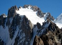
Coronet Peak in Ala Archa - Photo: sport.akipress.org
Coronet Peak is a mountain at the head of the Ala Archa Gorge, which lies about 40 kilometers, (just under an hour’s drive), to the South of downtown Bishkek.
The gorge is famous for its beautiful alpine scenery, (some consider it to be the most picturesque of the mountain valleys in the Kyrgyz Ala Too Mountain Range), and in 1976 it was designated a National Nature Park, in order to protect the natural environment and help preserve the rare and vanishing variety of wildlife, both fauna and flora … as well as to provide a resource for cultural and educational recreation and develop tourism and mountain climbing.
For the record: In Kyrgyz Ala means many coloured but when applied to mountain ranges it means “snowy” and is usually used to indicate mountains that have a have a permanent snow cover. Archa is the name given in Kyrgyz, to the Juniper tree which is found in abundance in the valley.
The park stretches for some 18 kilometers up the valley, covering about 194 square kilometers and the altitude varies from 1500 to 4895 meters above sea level. It contains within its boundaries something like 50 mountain peaks, 20 glaciers, waterfalls and springs feeding two major rivers. It is included on several lists of Highlights of Kyrgyzstan, things that could be considered a “must” for visitors to the capital to see and experience. It is also a favourite spot for locals, many of whom visit at weekends during the summer, who arrive for a day trip, to relax in the cool mountains, picnic. Some come for a few days and stay in one of the hotels or camps and others, mountaineers, come to tackle the various peaks – many of which are over 4000 meters high, for example: Semenova Tian-Shanskiy, (4895m); Bailyan-Bashi (4,700m);Free Korea Peak, (4650); Skryabina (4,650m); Ak-Too, (4600m); Uchitel (4,527m); Baichichekei (4,515m); Tecke-Tor, (4441m); Simagin, (4,400m); Dvurogaya (4,380m); Box, (4200m); Cosmonavtov (4,200m) … and, of course, Corona Peak, (Peak Carona or Coronet Peak, 4855m).
Corona peak lies at the head of the Ak Sai glacier and comprises six individual peaks, (or towers), arranged in a semicircle, or horseshoe … or crown – hence the name Coronet Peak.
Tower 1: 4240m
Tower 2: 4750m
Tower 3:
Tower 4:
Tower 5: 4860m
Tower 6: 4860m
As in most mountain regions, the weather can change suddenly – and temperatures can be extremely low. Although there are glaciers below the peaks, snow does not stick to the 900m high rock walls of the towers with slopes of about 70-90 degrees and are clean.
The view from the summit offers a panorama of some of the highest peaks of the Kyrgyz Range – weather permitting.
There are something like 160 different well established trekking and mountaineering routes of different levels of difficulty, which means that almost everyone can find something within their own capabilities, (apparently, on some of the routes, the ascent of Coronet Peak is accessible to beginner climbers, whilst others are more demanding … by all accounts, considerably more demanding), with the Northern wall is more severe than the Southern one.
At the foot of the mountain, on the confluence of the Ak-Sai and Crown glaciers at altitudes of 3500 to 3800m, there are a number of huts which are fitted with simple kitchens, and offer refuge for mountaineers making the ascent of the nearby peaks as well as a camp site which can accommodate about 40 tents.
(From the lofty mountain tops there are a number of glaciers which can stretch for as much as 15 kilometers and reach a width of 500 meters.)
Here is a video clip from b-live, (a local equivalent of youtube), of an ascent of the second tower in 2007:



 Bishkek