Water, water everywhere …
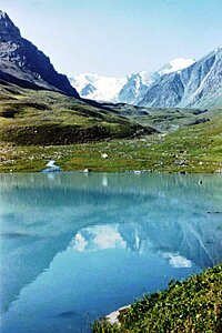
Shamsy Tuyk alpine lake lake
Today is World Water Monitoring Day, and water has been very much in the news quite a lot recently.
World Water Monitoring Day was established by America’s Clean Water Foundation in 2003 as part of a program to encourage public awareness and involvement in protecting water resources around the world, encouraging and empowering citizens to carry out basic monitoring of their local water bodies; lakes reservoirs and so forth.
Students around the world can utilise a simple kit to sample local bodies of water for a variety of factors such as temperature, acidity, clarity and dissolved oxygen, with results being uploaded to a global database.
As it happens, the mountains of Kyrgyzstan are the source of many rivers that flow through the territory of the country and then across its borders to its neighbours. Many are fed by melt water from glaciers high in the mountains and along their course they provide water for the irrigation of crops, drinking water, industrial and domestic use as well as the generation of power.
Reservoirs form an important part of the Kyrgyz landscape as well as providing an vital tool for water management. Whether they were created as part of the hydro-electric resource or for water management, they offer a valuable resource which has yet to be fully utilized for recreation purposes. Although it is possible to visit some of the over 30 reservoirs in the country – special arrangements may have to be made.
The first one to be built in Kyrgyzstan was the Orto Tokoi reservoir on the Chui River, outside Kochkor, in 1956. Another important reservoir is The Kirov Reservoir which is found in the Talas region and used extensively for irrigation – although the waters also provide resources for recreation. The most notable of course, is the Toktogul Reservoir which is important for both hydroelectric power generation and irrigation.
For the record: Basic facts for the major reservoirs are as follows:
| Reservoir | Year of construction |
River | Capacity Volume (millions of cu. m.) |
Area (sq.km) |
Maximum Height (m) |
| Toktogul | 1974 | Naryn |
19,500 |
284 |
215 |
| Andijanskoye | 1978 | Karadarya |
1750 |
||
| Kirov | 1975 | Talas |
550 |
27 |
83.7 |
| Orto Tokoi | 1956 | Chu |
470 |
25 |
52 |
| Kurpsayskoye | 1981 | Naryn |
370 |
12 |
110 |
| Papanskoye | 1981 | Ak Bura |
260 |
7 |
120 |
| Turtkulskoye | 1971 | Isfana |
90 |
73 |
|
| Uch Korgonskoye | 1964 | Naryn |
53 |
4 |
31 |
| Naimanskoye | 1968 | Abshir Sai |
40 |
3 |
41 |
| Ala-Archinskoe | 1968 | Ala Archa |
39 |
5 |
22 |
| Bazar Korgonskoye | 1962 | Kara Unkur |
30 |
3 |
25 |
| Sokolukskoye | 1968 | Sokuluk |
12 |
2 |
28 |
The major reservoir in the country is, of course, the Toktogul reservoir, although more recent projects to construct the Kambar Ata I and II power stations further up the Naryn River will somewhat over shadow it.
The Toktogul Reservoir is important for both the generation of Hydro electric power and also for regulating the water supply downstream for irrigation, domestic and industrial purposes.
President Karimov of Uzbekistan has recently been reported for making angry noises in speeches about the plans of neighbouring states to dam rivers for hydroelectric projects. Some analysts think that the situation could lead to a military conflict.
Although he, apparently, didn’t name those states, it is obvious that he was referring to Kyrgyzstan and Tajikistan. They are both reviving Soviet era proposals, for example: Kambar Ata in Kyrgyzstan and Rogun in Tajikistan both of which are receiving support from the Russian Federation. . The Rogun dam, if built, would be, at 335m tall, the world’s highest man-made dam – but this particular project is currently on hold awaiting a World Bank assessment . These projects will not only provide for hydroelectric power, but also restrict access to water downstream, (primarily in Uzbekistan and Kazakhstan), for agricultural purposes, (especially irrigation), industrial and domestic users.
In the past few years there have been a number of occasions when the issue has already raised tensions, as the nations upstream withhold waters in summer months, when needed for irrigation downstream, in order to raise water levels behind the dam, but release water in winter, when excess waters cause havoc downstream, in order to generate electricity.
In fact, there is nothing new in this situation … shorty after arriving here, for example, I met several people, (both international consultants and local officials, who were eagerly investigating the technical and legal questions and looking at international experience from the building of the Aswan High Dam and before, down to the present.
Also, several years ago, in a report on this potentially contentious issue, the International Crisis Group reported on Uzbek military manoeuvres which, they said, looked suspiciously like a rehearsal for taking over the Toktogul reservoir and hydroelectric power station.
In recent years the issue has assumed a new level of significance – partly because of the varying levels of water in the reservoirs. In 2008, for example, the water levels in the Toktogul Reservoir fell to their lowest for many years, and great concern was expressed that if the flow of water out of the reservoir was not stemmed, then water levels would soon fall sufficient to call it “empty”. It was necessary to ration the use of electricity by introducing such measures as: rolling power cuts throughout the country and removing the “Third Phase” supply to the population. Some analysts have cited this as one of the contributory causes to the popular unrest that led to the 2010 revolution, toppling the Bakiev regime.
There are even those who say that the “authorities”, instead of harvesting all the water in the reservoirs, had “sold” it, leading to the shortage, the remedial measures and by extension the unrest – and hence had “received their just desserts” …
The state of the Toktogul reservoir is very important to Kyrgyzstan and is regularly the subject of press reports. With a capacity of almost 20 billion cubic meters, it has spent the year fluctuating somewhere around the 16, 17, 18 billion mark, but it is currently about 2 billion less than was stored at this time last year … AND it is expected to fall to about half full over the winter as water is drained off to power the generators, reaching about 10 billion cubic meters in April – which is pretty close to the minimum level when the power station would have to be shut down to prevent damage to the turbines. What’s more, current models suggest that there might not be a sufficient flow of water into the reservoir in 2013 in order to provide sufficient generating capacity for the following winter.
It seems, according to comments made by Roza Otunbaeva at a conference in Montreux, that the International Monetary Fund and the World Bank are going to try and help Central Asian States address and resolve such cross border River issues … and I suppose we will have to wish them success in tackling this thorny issue – especially as water is just such a “thorn” to be dealt with.
There has been some considerable research into the effect of building reservoirs. The large surface area makes for increased evaporation, resulting in the loss of water which can be an important factor in arid and semi arid climates such as are encountered in Central Asia. There is evidence that the construction of dams can affect the composition of the water, reduce the flow and laying of sediment downstream and even raise temperatures affecting the local micro-climate.
The fact that most of the rivers are fed from glacial melt water causes some concern as it appears that the glaciers are retreating as a consequence of global warming. The Petrov glacier, for example, which is near to the Kumtor Gold mine has retreated some 800m in the last 50 years.
There are several international monitoring projects and this provides an easily identifiable issue for groups to focus upon when seeking to protest, in particular, against mining projects.
As does the quality of the water supply downstream. Although there have been projects designed to bring piped water to remote villages, many still do not have this and draw their water from local wells or streams. As a result, the question of pollution is one which quickly arouses strong feelings.
In recent weeks there have also been a growing number of news stories about high mountain lakes about to burst their banks, releasing large quantities of water cascading into the outflow rivers which would cause flooding downstream. We’ve seen it happen occasionally, and a few years ago, (2003), the Ala Archa river burst its banks in the Kashaka Suu region, taking several bridges and dachas in the flood waters.
|
Altitude interval |
No. of lakes |
|
4001 – 4500 |
2.9 |
|
3501 – 4000 |
37.6 |
|
3001 – 3500 |
46.7 |
|
2501 – 3000 |
3.8 |
|
2001 – 2500 |
2.3 |
|
1501 – 2000 |
5.1 |
|
1001 – 1500 |
0.7 |
|
501 – 1000 |
0.9 |
|
Total number of lakes |
1923 |
In total, there are almost 2000 lakes in the Kyrgyz Republic, with a combined area of 6836 sq km. Most of them are small mountain lakes, located at altitudes between 2500 and 4000m asl and were formed as a result of glaciations. According to the Ministry of Emergency Situations, over 350 of these are prone to “flash flooding”.
In fact the Ministry issued a warning a few years ago that in the near future we could expect to see several of the high mountain glacial lakes burst their banks. As if to fulfil that prediction, earlier this year we saw warnings about one particular lake just South of Bishkek that is fed by the Adygene glacier and which was perilously close to overflowing and threatened to flood a number of villages to the South of the city. The authorities were adamant that the resulting floods would not approach Bishkek, but people were getting nervous.
As an aside: it is worth remembering that Bishkek was chosen as the capital, replacing the then administrative centre which located at that time in Tokmok, because the Chui river burst its banks submerging that town.
The effect of glacier melt has had a significant effect on the volume of water held in the lakes. Thirty years ago one of the lakes fed by the Adygene glacier held just 30,000 cubic meters of water, but this year it isa estimated to hold ten times as much. As the Petrov glacier, (near to the Kumtor gold mine), has retreated, the depth of the Petrov Lake has apparently more than doubled in the last 50 years from 30 to 70m.
Earlier this week, a Parliamentary committee heard how there were several lakes which could breach their banks … it depended which news report you read if this was 13 or 37, although there was agreement that most of the glacial lakes that posed a risk were to be found in the Chui region, and then Issyk Kul.
The Ministry has been working with experts from the Czech Republic and identified several civil engineering works which could help to resolve the situation and offer protection to those communities downstream, but they tend to be expensive, (according to one report, costing a million som for a hundred meters of work strengthening banks), and, at the moment, the ministry doesn’t have the level of funding needed to undertake the work.
Fortunately, most of the alpine lakes that pose some form of threat are remote from population centres.
Presumably to mark World Monitoring Day, the Ministry of Agriculture and Melioration of Kyrgyzstan announced yesterday that various activities are planned to support the work of the Water Users Association in the implementation of the Water Code of Kyrgyzstan.
For more information on World Water Monitoring Day, see the official website. This year they are anticipating almost 55,000 participants in over 36 different countries – but, unfortunately, that doesn’t seem to include Kyrgyzstan. Maybe next year!
UPDATE:
I came across this today which I think provides food for thought:
http://www.youtube.com/watch?v=DE62iCobNSE
22/09/2012





 Bishkek