Kyrgyzstan’s Rivers
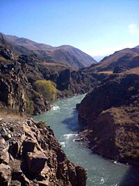
The Chui River
Water is one of the great natural resources of Kyrgyzstan.
The mountains are the source of many rivers that flow through the territory of the Kyrgyz Republic and across its borders to its neighbours. The mountain streams and rivers are dammed for hydro electrical production and the reservoirs thus created, in theory, allow the tiny republic to control the flow of rivers and thus controlling and rationing water supply to its neighbours. This has been the cause of some disputes and it is sometimes held that water could be a flashpoint for future conflict in the region, (as it could be in many other parts of the world). In one of their reports, the International Crisis Group even suggests that Uzbekistan held military manoeuvres that looked suspiciously like a practice for the seizure of the Toktogul reservoir.
Indeed, in 2008 the water levels in the Toktogul Reservoir fell to their lowest for many years, and great concern was expressed that if the flow of water out of the reservoir was not stemmed, then water levels would soon fall sufficient to call it “empty”. It was necessary to ration the use of electricity by introducing such measures as: rolling power cuts throughout the country and removing the “Third Phase” supply to the population.
There are more than 40,000 rivers and streams in Kyrgyzstan with a combined length of roughly 150,000 km and draining some 47 cubic km of water a year.
The main source of water for the rivers is melt water from the numerous glaciers and snowfields in the mountains. The contribution of rainfall amounts to less than one fifth of the water flow.
Most of the mountain streams are not really navigable due to the extreme drop in altitudes, the complicated relief of the riverbeds and the velocity of the river flow. Many of them, however, are suitable for white water rafting and similar activities. In the past, there was a logging industry which used the mountain streams for transportation, but this has long since ceased.
Up until about a century ago, small craft made of skins, rather like coracles, were still in use. They have since been replaced by ones made of more conventional materials such as wood.
We sometimes get asked for detailed information about specific rivers – especially by people interested in rafting or canoeing expeditions. We can’t always provide the answers – for example the rate of flow along the River Naryn at different stages along its 535 kilometres, but here is some basic information about some of the main rivers in the Kyrgyz Republic:
The River Naryn is the longest river in Kyrgyzstan, (535 km in length) and is in fact a river famous from antiquity as the Amu Darya. Formed by the confluence of the Big and Little Naryn Rivers, just above the town of Naryn, it collects the waters of several large tributaries such as the At Bashi and Kekemeren until flows into the Toktogul Reservoir and the flows south breaking through the Ferghana Range into the Ferghana valley … and then amasses yet more tributaries until eventually it flows as the Amu Darya into the Aral Sea.
Nowadays, extensive cotton farming in Uzbekistan absorbs most of its waters, so that the Aral Sea is drying up. It is possible to travel from the town to the source of this once famous river. Downstream, in Kyrgyzstan, the river is used extensively for hydroelectric power generation and it flows into the giant Toktogul Reservoir that you would see if you used the main Bishkek-Osh road. The river is a potential source of friction with Uzbekistan, since Kyrgyzstan wants to retain more of the water for its own uses.
The Talas – although a major river, it is perhaps best known because it was on the banks of the river in 751 that the Chinese suffered the defeat that marked the end of the Westwards expansion – and released the secrets of the manufacture of paper and silk to the wider world.
The Chui (or Chu) in the North which flows from the Naryn region, around the eastern edge of the Kyrgyz Krebet, through Book Gorge and then the Chui valley past Bishkek and finally dissipates into the deserts of Kazakhstan. It was once thought that the river flowed out of Lake Issyk Kul, but this is not true, it swings around the mountains and cuts a course that misses the lake by several kilometers. In the Bishkek region the Southern flank of the valley is formed by the Kyrgyz Krebet mountain range – and the Northern flank by the gentle Jalanash hills in Kazakhstan. The valley is intensively irrigated.
The Sary Jaz, which rises from the slopes of the Khan Tengri massif and flows past some impressive peaks, swinging into China. In 2003, the suggestion was made that to build another road to cross the border through the valley. Although it is possible to trek in the region, the conditions are such that it is not for beginners – experience and fitness is a requirement.
The Chatkal – Located in the Western Tian Shan mountain range, the River Chatkal flows through a remote valley in the extreme West of the country and into Uzbekistan. It is flanked by the 120 km long mountain range of the same name and the Chandalash range. In the past it was possible to raft down the river into Uzbekistan – but border problems and changes in the visa regime have made this itinerary extremely difficult to organize.
| River | LengthKm | Size of River basin 000’s sq. km |
| Naryn | 616 | 50.1 |
| Talas | 294 | 10.8 |
| Chui | 221 | 22.8 |
| Kara Dary | 189 | 16.2 |
| Sary Jaz | 165 | 12.1 |
| Chatkal | 155 | 6.9 |
| Kyzyl Suu (in the Alai valley) |
128 | 7.8 |
| Kekemeren | 108 | 8.3 |




 Bishkek