The Bishkek-Naryn Road
I’m off to Naryn for my regular monthly visit to the guesthouse.
The main road from Bishkek to Naryn offers a wide variety of landscapes, and although I know the route well, travelling it about 150 times, (at least once a month over the last twelve and a half years), I never tire of the range of different scenes that unfold before your eyes along it.
The road heads East from Bishkek along the wide Chui valley with mountains in the distance on the right hand side. Actually, unusual in Kyrgyzstan, the traveller is faced with two possible alternative routes to chose between for this particular stretch of the journey.
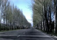
First, there is the “old” road, that runs virtually due east out of Bishkek and directly towards Lake Issyk Kul. Lined with trees in places, it passes through a couple of towns and a number of ribbon development villages, crossing the railway line at a couple of points. It makes for an for an interesting drive, with many things to see as you pass through the conurbation of settlements, and the trees help to shade the car from the glare of the sun. However, it is quite a busy road with lots of local traffic and passing through the settlements means that it is difficult to build up and maintain any consistent speed.
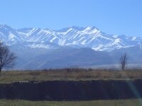
Then there is the “new” road – built sometime in the 1960s, which is longer but bypasses the many villages. For much of its length is a dual carriageway which means that you can maintain a reasonable speed and so it is often preferred for this reason. It offers a more open view of the snow capped mountain peaks to the south and for a time runs parallel to the Chu River, which forms the border with Kazakhstan. (In fact, at one point you cross the river into Kazakhstan – but only for a short distance and you don’t need a visa). Both countries have constructed watchtowers at points along the border to help deter locals from smuggling contraband across what was once just an administrative border between two constituent republics of the former Soviet Union and now comprise two independent states. This year the Kazakhs have also installed a barbed wire fence along their bank of the river.
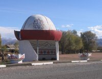
Eventually these two roads join once more and together they continue towards Issyk Kul, through the village of Nur which has what is probably the most photographed bus stop in Kyrgyzstan, in the shape of a Kalpak – the felt hats worn by male Kyrgyz. After the town of Kemin the road passes Holdnaya Voda, (“Cold Water”), centred around a freshwater spring, where there are a number of yurts and cafes that act as a “pit-stop” for weary travellers.
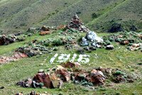
As it climbs towards Boom Gorge, (“Shoestring Gorge”), the Urkun memorial to those who suffered during the events of 1916, when the local population of Central Asia rebelled against the Russian authorities, only to unleash a violent repression to enter Boom Gorge – meandering between steep sided cliffs alongside the Chu River – climbing up towards Balykchi and Lake Issyk Kul.
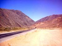
Crossing the river over “Red Bridge”, we leave the Chui oblast and enter the Issyk Kul region of Kyrgyzstan. Here, the rock formations are quite different from the craggy peaks of the Kyrgyz range. For those with an imagination, some of the patterns in the rock faces conjure up images of castles of fortresses. The gaping opening that we pass to the right is the entrance to the Konorchak Canyons, which many liken to the Grand Canyon in the United States.
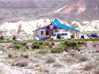
In recent years a number of cafés have sprung up along the narrow valley offering travellers an alternative to compete with the yurts of Holodnaya Voda. We normally stop off at one of them for cup of tea and a late breakfast.
The modern road through Boom Gorge is one of the best in the Republic, and it may surprising to reflect on the fact that the first attempt to drive a vehicle from Bishkek to Balykchy failed – it ran out of fuel. This might well be the reason for the petrol stations located by the bridge taking the new road over the river to the Kubiki Pass towards Kochor and Naryn. However, restrictions prohibit minibuses and buses from using it so it is only available to those travelling in an ordinary car – or, for some reason, lorries. Minibuses have to travel up to Balykchy and then turn South, adding both distance and time to their journey.
Having crossed the bridge over the river the road twists and turns, before entering a wide valley, climbing all the time towards the pass. Once over it there are spectacular views down towards the Orto Tokoi reservoir, the first ever to be constructed in Kyrgyzstan, towards which it rapidly descends. At the moment, this stretch of the road is under reconstruction, widening it so as to improve the main artery between Bishkek and the Chinese border.
Skirting the road joins the Balykchy-Kochkor road which undulates until it eventually reaches Kochkor. Then it steadily climbs once more towards the Dolon Pass, at 3025m above sea level. The road twists and turns following the Sary Bulak river upto the village with the same name where it takes a sharp turn. After you pass the turn off to Lake Son Kul, if continues climbing and a dramatic panorama of the valley beneath opens up.
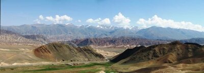
The Dolon Pass acts as more than just a watershed. The landscape is quite different and, often, the weather on the two sides is completely different from each other.
Most of the road to Naryn is asphalt, but the stretch over the pass is a gravel surface at the moment. Passing over the crest of the pass, on the Naryn side the road passes through a narrow gorge before opening out into a wide valley at the village of Ottuk, about 40km before Naryn. The gorge is so narrow in places that it is easy to understand how it is often blocked during the Spring by avalanches of snow, one year year cutting off Naryn from the rest of the country for over a week.
From Ottuk the road follows the undulations of the valley floor and it is at this point that I usually start counting the kilometers to Narynj as it feels as we’ve entered the “home straight” of the five hour journey.
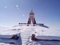
Twenty five kilometres from Naryn the road crests another rise and there in front of us it a striking memorial standing on top of a hill. It caught my attention the first time I saw it, but nobody could tell me anything about it. Eventually, on one trip I told the driver to stop at the foot of the hill, got out of the vehicle and started to climb the hill to take a closer look. That was a mistake. It was the middle of winter and snow lay thick on the ground. As I walked up the hill I sank in the snow, at first half way up my shin, then to my knees, then even deeper. I got well and truly soaked and it was bitterly cold even though the sun was shining and it was a brilliantly clear day.
The monument is to Arstanbek Buylash uluu , a Kyrgyz writer and poet. (In Kyrgyz, “uluu” is like Mac, Mc, O’, and Ben meaning “son of” so his names reads “Arstanbek, son of Buylash”). His dates as recorded on the monument are 1824-1878.
Astanbek is regarded as a major Kyrgyz poet, and is known as “the nightingale”, although few of his works survive. His music was widely played but his poems were proscribed during the Soviet period because of his independent standing and his stand for the protection of the traditions of his people many of which were under threat of disappearing. He was concerned about the influence of the Russian colonists of his day upon his native people and their culture. He composed poems about the “dark times” that were coming and the need for the Kyrgyz to preserve their traditions and their lifestyle. What remains were published for the first time in 1994 – to mark his 170th anniversary.
In the summer time – I wouldn’t recommend it in winter with snow on the ground – if you have the time, then the climb to the Monument is not difficult and the view across the plain is pleasant.
The road then drops quite steeply towards the town of Naryn itself.
About 10 kilometres out, there is a fork in the road. The road sign helpfully informs drivers that left fork leads to Naryn, as does the right fork! The left takes you to the eastern end of town, (where the guesthouse is), whilst the right fork takes you to the western end.





 Bishkek