The strange flow of the Chu River
It’s amazing what you come across when surfing the internet. I was caught by surprise one day this week when I cam across a blog entry that a simple question.
Lake Issyk Kul in North Eastern Kyrgyzstan is the world’s second largest mountain lake and stands at an altitude of 1600 meters above sea level. At its deepest point, the lake is 700 meters deep. Bishkek, the capital of Kyrgyzstan is situated in the plain of the Chui River and lies at just 700 meters above sea level – some 1100 meters below the bottom of the lake. It looks as if the Issyk Kul Basin and the Chui valley was once one large valley … so, why is it, the author asked, that the waters of the lake don’t flow out into the Chui?
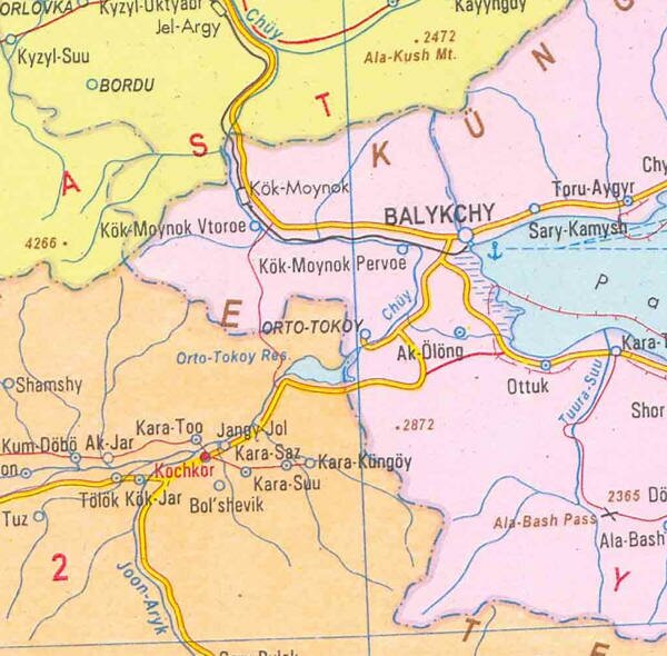
This caught me by surprise because just a couple of days before I had had the same conversation with one of our guides. He had been accompanying a group of tourists, one of whom was apparently a Geologist and had posed a similar question: “Why is it that the Chui River turns so abruptly just short of the lake rather than descending and flowing into it?”
At the time, I didn’t really think much about it apart from, perhaps, “That’s an interesting question … I wonder why?”
The blog entry, however, spurred me to look into further.
Now, the Chui River is one of the seven rivers that gave the Semirechye district of the of the Turkestan administrative region of the Tsarist empire, its name. In Russian, “semirechye” means “seven rivers”. (According to the Odyssey Guide to Kazakhstan, however, the seven rivers were the Ili, Shelek, Tentek, Lepsy, Aksuu, Koksuu Karatal). In modern Kazakhstan, there is still an administrative oblast called Zhetysu, (which means the same, “seven rivers”, in Kazakh), but this is much smaller than the area administered under this name by the Russians, which also incorporated parts of Northern Kyrgyzstan.
Incidentally, the river is called Chui in Russian, Chu in Kyrgyz and Shu in Kazakh.
It’s 1070 kilometer course starts from its sources in the Tien Shan mountains of Kyrgyzstan on the southern flanks of the Kyrgyz Range, South of Bishkek and the Central Tien Shan mountains, North of Naryn, After the confluence of Joon Aryk and Karakol rivers, just outside the market town of Kochkor, the waters flow eastwards through the Orto Tokoi Reserviour and on towards Lake Issyk Kul. They never actually make it to the lake, however, a few kilometers shy of Balykchy, the town on the Western tip of the lake, the river turns North West and enters Boom Gorge, eventually emerging into the plain of the Chui valley where, for about a hundred kilometers it forms the border between the two republics of Kyrgyzstan and Kazakhstan. Finally it entering the steppes of Southern Kazakhstan before it eventually disappears short of the Syr Darya River, into which it might well at one time have flowed.
One reason why it may not actually reach the Syr Darya any more, is that the river waters are diverted for irrigation purposes along its course. Indeed, the Orto Tokoi reservoir, (the first of kyrgyzstan’s thirty odd reservoirs), was constructed in 1956.
When the first Russian explorers ventured into the region, there was a generally held opinion that the river actually flowed out of Lake Issyk Kul, and Pyotr Semyenov surprised everyone by traveling up the canyon and showing that it didn’t.
However, it might well have done so, at one point in time.
At a workshop about Environmental issues surrounding the lake in 2000, V. V. Romanovsky from the Institute of Water Resources and Hydropower, reported that the waters of Lake Issyk Kul have risen and fallen, several times, over the years, citing geological evidence such as rock and soil samples gathered from the lake terraces and cliffs surrounding the lake, archaeological discoveries – both above and below the current water level, historical records and more recent instrumental readings.
During the two hundred years between about 1300 and 1500 AD, the evidence suggests that the water level was between two and five meters lower than it is today, but in the middle of the nineteenth century it was thirteen meters higher. It was also about thirteen meters higher about two thousand years ago and ancient writings suggest that the lake at that time had an outflow into Boom Gorge. An account written by a Russian engineer in 1878, drawing on reminiscences of old people in the region reported that fifty years before that, (that is, somewhere around 1830), the surface of the lake was two hundred feet higher than it was at that point, and extended some distance into Boom gorge itself. There are other reports of the lake having an outlet into the gorge, including two maps drawn in the late eighteenth century. On the other hand, a little earlier in the eighteenth century, and as early as the sixteenth century, there are sources which declare which that the lake sits in a “closed basin”.
So the water level seems to have risen and fallen considerably over the years – possibly, at times breaching the land “dam” at what is now its Western extreme, thus capturing the inflow from the Chui river only to discharge it again into the gorge, but at other times falling back and exposing the “dam”.
Indeed, during the nineteenth century, the water level was, apparently, receding so fast that concerns were expressed about the very sustainability of the lake. In 1905 a newspaper report was headlined: “Issyk Kul – A disappearing Sea Lake”.
As the water level in the lake fell, the Chui river seems to have sought out the easiest route for its waters to descend under the forces of gravity to the plains below. Blocked from entering the lake by a ridge of harder rock, it carved out its present course through softer rock, into the canyon and beyond. That softer rock took it through the semicircle, North to the head of the Gorge then through it heading West.
Now I am not a geologist and, to be honest, some of the technical detail in the paper is over my head, but it is an interesting suggestion and has, in a way, given me a little optimism … after all, I know that it is not really an analogous situation but if, despite the graphic predictions of 1905, Lake Issyk Kul hasn’t disappeared yet, maybe there is still hope for the Aral Sea … perhaps that too can still be preserved.


 Bishkek