Semyenovka and Grigorievka
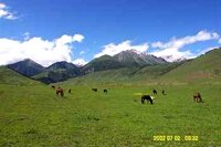
Jailoo in the Semyenovka valley
There are a number of beautiful valleys in the Kungey Ala-Too Mountains (The “Sunny” Ala-Too Mountains) on the Northern side of Lake Issyk Kul. The largest and best known of these are Grigorievka and Semyenovka – some 30 kilometers further on from Cholpon Ata as you travel from Bishkek.
Both of these valleys offer spectacular alpine scenery, (“some of the best” on the Northern shore), rushing mountain streams and both are worthy of separate mentions. However, they are often linked as there is a road over the pass between the two valleys – and for those with a day spare whilst relaxing in Issyk Kul, it makes a pleasant excursion into the mountains as an alternative to just sitting on the beach, soaking up the sun, all day.
The area is also popular for those seeking a more active holiday as it criss-crossed by trekking routes – some of which pass over the mountains towards the city of Almaty in Kazakhstan – and also down to Kaindi, (near the lake Jassyk Kul), in the Chon Kemin valley.
Semyenovka:
An asphalt road leads some 15 kilometers into the mountains from the village of Semyenovka, (named after the Russian explorer, Pyotr Semyenov “Tianshansky”), following the valley of the Chong Ak-Suu (“Big White Water”), past the Kyrchyn tourbaza which used to have a 240-bed hotel, and other facilities. The road leads to a jailoo (mountain pasture) at 2010 meters above sea level and the conurbation with the Kichi Ak-Suu (“Little White Water”) river. The river flows some 34 kilometers from the glaciers in the mountain peaks down into Lake Issyk Kul, through three small lakes.
The jailoo was historically used as a meeting place for congresses of Kyrgyz elders.
In the valley there is a skibase – opened in 2002.
On the north eastern edge of the village of Semyenovka, at the foot of the valley, are some graves dating from the 5th to the 3rd centuries BC. Some more lie further up the valley of the Ak Suu river.
Another piece of history – on the shores of Lake Issyk Kul, not far from the village of Semyenovka, is the dacha built in the 1960’s especially for the visit of Leonid Brezhnev – and used just once. A rather modest building, set at the edge of marshland, a short walk from the beach, it is now unfortunately in a sad state of disuse and disrepair, although apparently there are plans to renovate and restore it.
Grigorievka:
The Chon Ak Suu canyon is also known as Grigorievka – which is the name of the village on the main road at the foot of the valley.
This canyon is 32 kilometers long with a road the first 15 kilometers from Grigorievka. The slopes are covered with dense fir groves and littered with waterfalls. There are glacial lakes, and spectacular views of peaks and glaciers on the various trails over the mountains to Almaty, as well as the trail to Chon Kemin.
The village at the foot of the valley, has a memorial to the fallen in the Second World War bearing the names of 250 local people who died in the conflict.
____________________
During the season, both valleys also offer the opportunity to stop at a roadside yurt, order shashlik and tea, take a short ride on a horse, of have a photo taken whilst holding an eagle on your arm.
During the Soviet period the passes at the top of the Seyenovka and Grigorievka valleys across to Almaty in Kazakhstan were popular trekking routes. However, when the internal “administrative” borders of the USSR were replaced by “International” borders, the legal procedures which require that borders are crossed only at official border posts meant that these routes were effectively closed to the ordinary trekker – although arrangements can be made for those who do want follow in the footsteps of the Russian pioneer and explorer Pyotr “Tienshansky” Semyenov.




 Bishkek