Kyrgyz Mountains
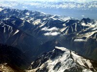
Over 94% of Kyrgyzstan lies at an altitude of over 1000 meters above sea level and 71% above 2000 meters. (Generally – anything above 1500 meters is counted as mountainous).
As a result it may not be surprising that when the United Nations declared 2002 as the International Year of the Mountains, the culminating highpoint of the year was the Bishkek Global Mountain Summit. Representatives from many intergovernmental agencies and other “mountainous” countries met to consider issues relating to life of people inhabiting the various mountain areas of the world. For the record: the idea for such a project had been proposed by President Akaev of the Kyrgyz Republic, and a similar summit is planned for 2010 – possibly the only time when such an international gathering returns to the same venue for its second session.
Amongst the mountains to be found in Kyrgyzstan are a number of 7000-meter peaks; many peaks which have been climbed only in relatively recent times; many virgin peaks – yet to be climbed and some mountains that are even reputed to be nameless.
It has been suggested in the Western press that there is a “Name that mountain” scheme where, in exchange for a fee, it is supposed to be possible to have a peak named after you. However, no-one here knows of such a scheme and it seems to be just another “modern myth”. It is true, however, that peaks are being names, for example:
- in 2002 a 5000 peak was named after former Russian President Boris Yeltsin and
- another peak was named in honour of the Kyrgyz Police,
- in 2003 a team from Azerbaijan were reported to have climbed a 5632 meter peak and named it “Azerbaijan Peak”; and
- a mountain with two peaks was climbed and named “9/11” in memory of the events in New York on September 11th, 2001
- in 2007 a mountain was named after Santa Clause – as it had been identified by some Swedish scientists as the best logistical sport for him to begin annual journey distributing gifts to the world’s children (!)
It is not clear if these are examples of previously unnamed peaks or simply renaming them – some of the more well peaks have already been known by several different names, which can sometimes lead to confusion.
There are over 88 major mountain ranges in Kyrgyzstan, most of them forming the Tien Shan System – the Celestial Mountains. The others, such as the Chon Alai range in the South of the country belong to the Pamir system. They effectively divide the country into a number of quite distinct regions – especially between the North and the South, there is only one road connecting them (the main Bishkek-Osh road).
Most of the ranges vary in length from 100 kilometres to 300 kilometres – the longest, (Kakshaal) is 582 kilometres long and the Kyrgyz Range, lying to the South of Bishkek, is 454 kilometres long. Most ranges are between 10 and 40 kilometres wide.
- The Tien Shan - the largest mountain range in Asia, in surface area; length (2800km); and width (at one point reaching 800 km wide) – with a total of 40 peaks over 6000m.
- The Terksey Ala Too range – (the “shady” mountains) – is located along the Southern shores of Lake Issyk Kul.
- The Kungey Ala Too range – (the “sunny” mountains) – is located along the Northern shores of Lake Issyk Kul – and form the border with Kazakhstan.
- The Kyrgyz Ala Too range run from Lake Issyk Kul across the Northern length of the country – about 40 km South of Bishkek.
- Kokshaal Range with Victory Peak
- The Talas range
- The Chatkal range in the extreme West of the country;
- The Ferghana range
- The Pamirs are found in the South of the country. Actually, only the most Northerly ranges of the system are in Kyrgyzstan – the Zaalaisky ridge
- The Pamir-Alai Mountains – which separate the Pamirs and the Tien Shan – consists of the Turkestan (including a number of virgin peaks) and Alai ridges and the Chon-Alai, with Peak Lenin .
The ranges which are snow-capped throughout the year are distinguished by the phrase “Ala Too” – although in Kyrgyz the phrase means “many colours” – or “colourful” – or “bright mountains”. The snow-line lies at about 3600 meters.
The mountains of Kyrgyzstan hold many attractions for mountaineers and trekkers. For most of the Soviet period, (or as some locals refer to it – “in former times”), the region was off-limits to foreigners and even Soviet mountaineers had trouble obtaining the permissions necessary for an expedition. Although the system is less rigid these days, there are still some restrictions, and permits necessary, in certain areas – especially in the border zones.
The difficulties faced by mountaineers are exacerbated by the weather – it can snow suddenly and for several days at a time – increasing the risks of avalanches and crevices.
The relief of the mountains varies extensively from Massif to Alpine and many different types of landscape can be experienced. Woods tend to be located on North facing slopes, where snow lies longer whilst grassland meadows, (jailoo), tend to be located on southern facing slopes which benefit greater from the warming effects of the sun’s rays.
Here is a list of the some of the mountain ranges in the country with their highest peaks (from the “Encyclopaedia Kyrgyzstana”):
| Range | Length (in km) |
Width (in km) |
Highest peak | Highest Point (m. a.s.l.) |
Average Height (m. a.s.l.) |
| Koshaal Too | 582 | 54 | Pobeda (Victory Peak) | 7439 | 4500 |
| Chon Alai | 250 | 40 | Peak Lenin | 7134 | 5460 |
| Alai | 350 | 20 | Tandikul | 5880 | 4450 |
| Sari Jaz | 93 | 16 | Semyenov | 5816 | 4700 |
| Turkestan | 300 | 30 | Sabla | 5621 | 4430 |
| Terskey Ala Too | 354 | 40 | Karakol | 5280 | 4290 |
| Ak Shyirak Too | 60 | 28 | Djaman Suu | 5126 | 4720 |
| Ferghana | 206 | 62 | Kara Kuldja (Uch Seyit) | 4940 | 3620 |
| Kyrgyz | 454 | 40 | Zapadni Alamedin (Western Alamedin) | 4855 | 3700 |
| At Bashi | 140 | 30 | Uoyrme | 4786 | 4300 |
| Kungey Ala Too | 285 | 32 | Chok Tal | 4771 | 4200 |
| Chatkal | 225 | 30 | Chatkal (Aflatun) | 4503 | 3800 |
| Naryn Too | 120 | 18 | Baibichye | 4500 | 4200 |
| Talas | 260 | 40 | Manas | 4488 | 3930 |
| Djumgal | 54 | 15 | Min Teke | 4281 | 3800 |
Different sources quote slightly different figures for some of these statistics – and that is not surprising in that, (especially in some of the more remote regions), surveying is still being carried out. In one case a disputed figure is blamed on a faulty altimeter being used by a party of climbers – giving a misleading figure.
In particular: until recently Khan Tengri was thought to be only 6995 meters high – but the figure has been revised (and some people treat the new measurement of 7010 meters with an element of suspicion).
The country is so rich in peaks that there are some surprising omissions in this list. For example, the third major peak in the country, Khan Tengri, doesn’t appear simply because at only 7010 m. (or 6995 m.), its neighbour, Pobeda, is about 130 meters higher. Also missing from the list is Corona – or Crown Peak – which lies to the South of Bishkek.
The website http://www.summitpost.com/ (or http://www.summitpost.org/) gives the following table of “Principle Mountains in the Central Tien Shan” – of the 40 peaks listed, 27 are located in, or on the borders of, the Kyrgyz Republic:
| No. | Name | Other Name | Elevation | Country | ||
| 1 | Peak Pobeda | Mount Tomur | 7439 | China-Kyrgyzstan | ||
| 2 | Khan Tengri | Tengi Tag | 7010 | Kyrgyzstan-Kazakstan | ||
| 3 | Muzat I | 6955 | China | |||
| 4 | Pshavela | 6918 | China-Kyrgyzstan | |||
| 5 | Topografov | 6873 | China-Kyrgyzstan | |||
| 6 | Rapasova | 6814 | China-Kyrgyzstan | |||
| 7 | Drushby | 6800 | China-Kyrgyzstan | |||
| 8 | Pobeda East | Vostochnaya | 6762 | China-Kyrgyzstan | ||
| 9 | Neru | 6742 | China-Kyrgyzstan | |||
| 10 | Tamdyn I | 6670 | China | |||
| 11 | Shatior East | 6637 | Kyrgyzstan-Kazakhstan | |||
| 12 | Xueleng | Xuelian | 6627 | China | ||
| 13 | Nagela | 6565 | China-Kyrgyzstan | |||
| 14 | Yanamax | 6541 | China | |||
| 15 | Progrebietskovo | 6527 | Kyrgyzstan | |||
| 16 | Xueleng South Peak | 6527 | China | |||
| 17 | Przhewalskovo | 6440 | China-Kazakhstan | |||
| 18 | Tamdyn II | 6447 | China | |||
| 19 | Shatior West | 6435 | Kyrgyzstan-Kazakhstan | |||
| 20 | Khan Tengri | Temirsu | 6435 | China | ||
| 21 | Tereza | 6401 | China-Kyrgyzstan | |||
| 22 | Chapayeva | 6371 | Kyrgyzstan | |||
| 23 | Stina | Marble Wall | 6350 | China-Kazakhstan | ||
| 24 | Koxkar | 6345 | China | |||
| 25 | Chongteren | 6301 | China | |||
| 26 | Valikhanova | 6300 | Kyrgyzstan | |||
| 27 | RGO | 6278 | China-Kazakhstan | |||
| 28 | Stina South | 6265 | China-Kazakhstan | |||
| 29 | Zorge | 6210 | China-Kyrgyzstan | |||
| 30 | Proletarski | 6205 | China-Kyrgyzstan | |||
| 31 | Saladina | 6201 | Kyrgyzstan | |||
| 32 | Shipilova | 6201 | Kyrgyzstan | |||
| 33 | Skazka | 6200 | China-Kyrgyzstan | |||
| 34 | Aktua | 6181 | Kyrgyzstan | |||
| 35 | Plato | 6146 | China-Kyrgyzstan | |||
| 36 | Shiroki | 6120 | Kyrgyzstan | |||
| 37 | Kirova | 6072 | China-Kyrgyzstan | |||
| 38 | Muzat II | 6069 | China | |||
| 39 | Maxim Gorki | 6050 | Kyrgyzstan | |||
| 40 | Edelweiss | 6000 | Kyrgyzstan |
Those mountaineers that climb all five mountains in Central Asia which rise above 7,000 meters (three of which are located in the Kyrgyz Republic) receive a certificate and become a ‘Snowleopard’. Obtaining this honorary title is a very real ambition for many Russian climbers.
The five mountains are:
- Peak Communism (in Tajikistan – 7495m)
- Peak Pobeda (in Kyrgyzstan – 7345m)
- Peak Lenin (in Kyrgyzstan – 7134m)
- Korzhenevsky (in Tajikistan – 7105m)
- Khan Tengri (in Kyrgyzstan – 7010m)


 Bishkek